
North America
Bahamas — map and facts
Here you find a map of Bahamas, capital Nassau, currency Bahamansk dollar and quick links to more facts about the country in North America.
About the country
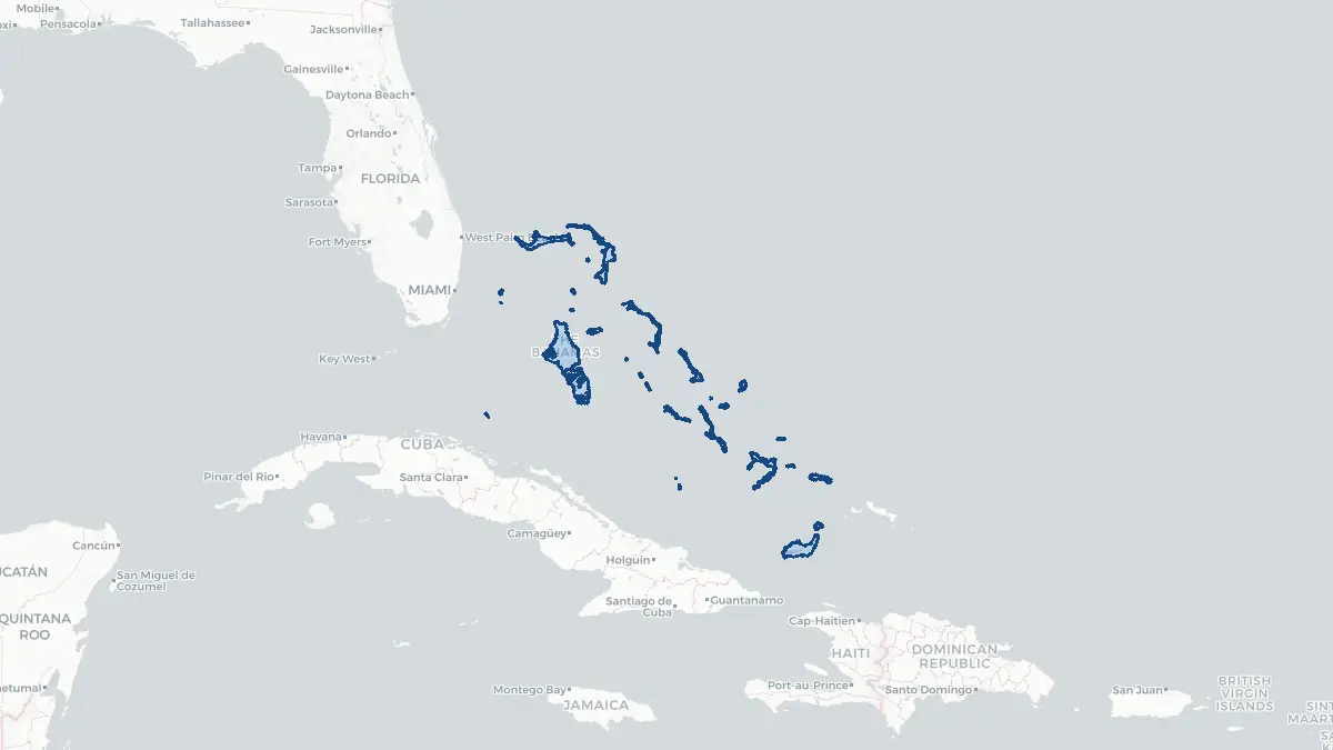
Bahamas on the map
About Bahamas
The Bahamas is a sovereign archipelagic nation in the northwestern Atlantic Ocean, lying to the north of Cuba and southeast of Florida. Its capital is Nassau, located on New Providence island. The population numbers approximately 400,000 people. The country became independent from the United Kingdom on 10 July 1973 and is a member of the Commonwealth of Nations, with King Charles III as head of state. The Bahamas has one of the highest per capita incomes in the Caribbean, driven primarily by tourism and offshore financial services. English is the official language. The currency is the Bahamian dollar, which is pegged at parity with the US dollar. The country is governed as a parliamentary democracy and constitutional monarchy. Nassau and the nearby Paradise Island, home to the large Atlantis resort, form the nation's commercial and tourist hub, while the so-called Family Islands remain more rural and sparsely populated.
Geography and Landscape
The Bahamas comprises approximately 700 islands and more than 2,400 cays and rocks, stretching over roughly 1,000 kilometres from the coast of Florida to just north of Haiti. The total land area is about 13,880 square kilometres, but the archipelago spans a vast marine territory. The islands are low-lying coral and limestone formations, rarely exceeding 60 metres in elevation, with the highest point being Mount Alvernia on Cat Island at 63 metres. The landscape is characterised by white and pink sand beaches, turquoise shallow waters known as the Bahama Banks, dense pine forests on some northern islands, and mangrove wetlands. The climate is subtropical, with warm temperatures year-round, moderated by Atlantic trade winds. Hurricanes pose a regular threat; Hurricane Dorian in 2019 caused severe destruction to Abaco and Grand Bahama islands. The shallow Exuma Cays Land and Sea Park is a notable protected marine area.
History
The Bahamas was home to the Lucayan people, a branch of the Taíno, when Christopher Columbus made his first landfall in the Americas on San Salvador island on 12 October 1492. Spanish colonisers subsequently enslaved and deported the entire Lucayan population to Hispaniola within decades, leaving the islands uninhabited. The English settled the Bahamas in 1648, when a group of Eleutheran Adventurers arrived seeking religious freedom. Nassau became a haven for pirates in the late seventeenth and early eighteenth centuries, including figures such as Blackbeard and Anne Bonny, before order was restored by Governor Woodes Rogers in 1718. The islands came under sustained British colonial rule, and loyalists from the American colonies arrived after 1783, bringing enslaved workers to develop plantation agriculture. Emancipation followed in 1834. The Bahamas gained internal self-government in 1964 and full independence in 1973 under Prime Minister Lynden Pindling.
Geo Quiz
Think you know your capitals, flags, and continents? Take the quiz!
Neighbouring countries
Continue to nearby countries
There are no registered neighbouring countries for Bahamas in the current database.
More countries in the same part of the world
North America index
Open the continent hub for North America to see the full country list, capitals and frequently asked questions on one page.
Interactive map
Zoomable map of Bahamas
Country index
All countries by continent
Jump directly to the right section or keep scrolling.
Africa
58 countries- Algeria
- Angola
- Benin
- Botswana
- Burkina Faso
- Burundi
- Central African Republic
- Djibouti
- Democratic Republic of the Congo
- Egypt
- Equatorial Guinea
- Ivory Coast
- Eritrea
- Ethiopia
- Gabon
- Gambia
- Ghana
- Guinea
- Guinea-Bissau
- Cameroon
- Cape Verde
- Kenya
- Comoros
- Republic of the Congo
- Lesotho
- Liberia
- Libya
- Madagascar
- Malawi
- Mali
- Morocco
- Mauritania
- Mauritius
- Mayotte
- Mozambique
- Namibia
- Niger
- Nigeria
- Reunion
- Rwanda
- Saint Helena
- Sao Tome and Principe
- Senegal
- Seychelles
- Sierra Leone
- Somalia
- Sudan
- Swaziland
- South Africa
- South Sudan
- Tanzania
- Chad
- Togo
- Tunisia
- Uganda
- Western Sahara
- Zambia
- Zimbabwe
Asia
52 countries- Afghanistan
- Armenia
- Azerbaijan
- Bahrain
- Bangladesh
- Bhutan
- British Indian Ocean Territory
- Brunei
- Myanmar
- Philippines
- United Arab Emirates
- Georgia
- Hong Kong
- India
- Indonesia
- Iraq
- Iran
- Israel
- Japan
- Yemen
- Jordan
- Christmas Island
- Cambodia
- Kazakhstan
- China
- Kyrgyzstan
- Cocos Islands
- Kuwait
- Laos
- Lebanon
- Macau
- Malaysia
- Maldives
- Mongolia
- Nepal
- North Korea
- Oman
- Pakistan
- Palestinian Territory
- Qatar
- Saudi Arabia
- Singapore
- Sri Lanka
- South Korea
- Syria
- Tajikistan
- Taiwan
- Thailand
- Turkey
- Turkmenistan
- Uzbekistan
- Vietnam
Europe
53 countries- Albania
- Andorra
- Belgium
- Bosnia and Herzegovina
- Bulgaria
- Cyprus
- Denmark
- Estonia
- Finland
- France
- Faroe Islands
- Gibraltar
- Greece
- Guernsey
- Ireland
- Iceland
- Isle of Man
- Italy
- Jersey
- Kosovo
- Croatia
- Latvia
- Liechtenstein
- Lithuania
- Luxembourg
- Macedonia
- Malta
- Moldova
- Monaco
- Montenegro
- Netherlands
- Norway
- Poland
- Portugal
- Romania
- Russia
- San Marino
- Switzerland
- Serbia
- Slovakia
- Slovenia
- Spain
- United Kingdom
- Svalbard and Jan Mayen
- Sweden
- Czech Republic
- Germany
- Ukraine
- Hungary
- Vatican
- Belarus
- Aland Islands
- Austria
North America
42 countries- U.S. Virgin Islands
- Anguilla
- Antigua and Barbuda
- Aruba
- Bahamas
- Barbados
- Belize
- Bermuda
- Bonaire, Saint Eustatius and Saba
- British Virgin Islands
- Cayman Islands
- Costa Rica
- Curacao
- Dominica
- Dominican Republic
- El Salvador
- Grenada
- Greenland
- Guadeloupe
- Guatemala
- Haiti
- Honduras
- Jamaica
- Canada
- Cuba
- Martinique
- Mexico
- Montserrat
- Netherlands Antilles
- Nicaragua
- Panama
- Puerto Rico
- Saint Barthelemy
- Saint Kitts and Nevis
- Saint Lucia
- Saint Martin
- Saint Vincent and the Grenadines
- Saint Pierre and Miquelon
- Sint Maarten
- Trinidad and Tobago
- Turks and Caicos Islands
- United States
South America
14 countriesOceania
27 countries- American Samoa
- Australia
- Cook Islands
- Fiji
- French Polynesia
- United States Minor Outlying Islands
- Guam
- Kiribati
- Marshall Islands
- Micronesia
- Nauru
- Niue
- Northern Mariana Islands
- Norfolk Island
- New Caledonia
- New Zealand
- Palau
- Papua New Guinea
- Pitcairn
- Solomon Islands
- Samoa
- Tokelau
- Tonga
- Tuvalu
- Vanuatu
- Wallis and Futuna
- East Timor