
North America
Honduras — map and facts
Here you find a map of Honduras, capital Tegucigalpa, currency Lempira and quick links to more facts about the country in North America.
About the country
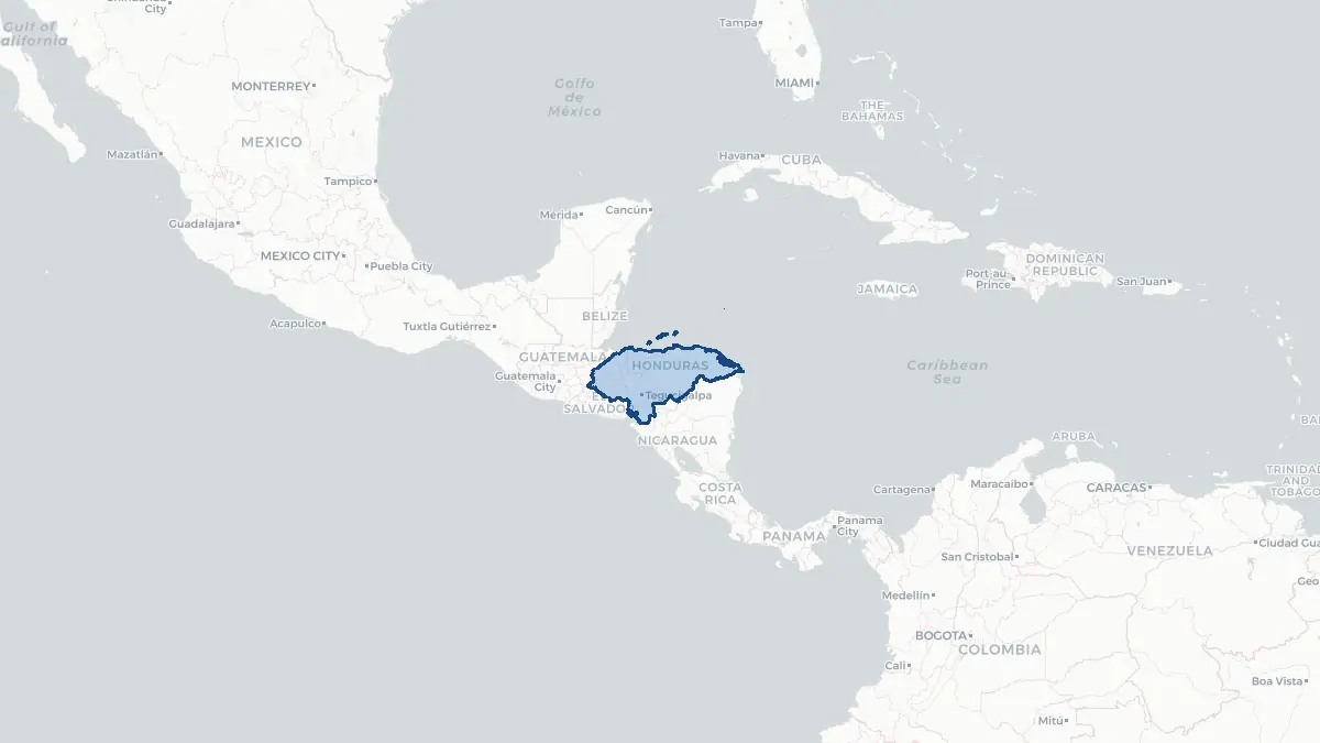
Honduras on the map
About Honduras
Honduras is a Central American republic bordered by Guatemala to the west, El Salvador to the southwest, and Nicaragua to the southeast, with the Caribbean Sea to the north and a short Pacific coastline on the Gulf of Fonseca to the south. The capital is Tegucigalpa, a mountainous city of approximately 1.4 million people. The total population is around 10.3 million. Honduras is the second-largest country in Central America by area, covering 112,492 square kilometres. The country has a presidential system of government and has experienced significant political turbulence, including a coup in 2009 and contested elections in 2017. Xiomara Castro became the first female president in 2022. Honduras is among the poorest and most unequal countries in the Western Hemisphere, with an economy based on remittances, maquila manufacturing, coffee, bananas, and palm oil. Gang violence and organised crime have driven high homicide rates, though these have declined in recent years from peak levels in the early 2010s.
Geography and Landscape
Honduras is predominantly mountainous, with highlands covering more than three-quarters of the national territory. The interior is crossed by several mountain ranges including the Cordillera Nombre de Dios along the Caribbean coast and the Montañas de Comayagua in the centre. Cerro Las Minas, at 2,870 metres, is the highest peak and lies in the Celaque massif near the border with Guatemala. The Ulúa and Aguán rivers drain the fertile Caribbean lowlands, which are the country's most important agricultural zones, particularly for banana cultivation. The Comayagua Valley is a broad, fertile basin in the centre of the country. The Bay Islands — Roatán, Utila, and Guanaja — lie in the Caribbean Sea offshore and are known for coral reef ecosystems. The Río Plátano Biosphere Reserve in the Mosquitia region of La Mosquitia covers one of the most extensive tropical rainforests in Central America. The Pacific coast on the Gulf of Fonseca is narrow but strategically significant.
History
Honduras was home to the Maya civilisation, particularly at Copán, which flourished as a major Maya city-state from the fifth through ninth centuries AD and is now a UNESCO World Heritage Site. Spanish colonisation began in 1524 under Hernán Cortés and his lieutenant Cristóbal de Olid. The region was incorporated into the Captaincy General of Guatemala. Honduras gained independence from Spain on 15 September 1821 as part of the Central American independence movement and was briefly part of the First Mexican Empire before joining the Federal Republic of Central America. Full independence came in 1838 when the federation dissolved. The late nineteenth and early twentieth centuries were dominated by North American banana companies — particularly the United Fruit Company and Standard Fruit — giving rise to the term "banana republic." A series of military governments ruled through much of the twentieth century. The 1969 Football War with El Salvador, fought over immigration tensions, lasted just one hundred hours. A peace treaty was signed with El Salvador in 1980, and civilian democratic rule was re-established in 1981.
Geo Quiz
Think you know your capitals, flags, and continents? Take the quiz!
Neighbouring countries
Continue to nearby countries
More countries in the same part of the world
North America index
Open the continent hub for North America to see the full country list, capitals and frequently asked questions on one page.
Interactive map
Zoomable map of Honduras
Country index
All countries by continent
Jump directly to the right section or keep scrolling.
Africa
58 countries- Algeria
- Angola
- Benin
- Botswana
- Burkina Faso
- Burundi
- Central African Republic
- Djibouti
- Democratic Republic of the Congo
- Egypt
- Equatorial Guinea
- Ivory Coast
- Eritrea
- Ethiopia
- Gabon
- Gambia
- Ghana
- Guinea
- Guinea-Bissau
- Cameroon
- Cape Verde
- Kenya
- Comoros
- Republic of the Congo
- Lesotho
- Liberia
- Libya
- Madagascar
- Malawi
- Mali
- Morocco
- Mauritania
- Mauritius
- Mayotte
- Mozambique
- Namibia
- Niger
- Nigeria
- Reunion
- Rwanda
- Saint Helena
- Sao Tome and Principe
- Senegal
- Seychelles
- Sierra Leone
- Somalia
- Sudan
- Swaziland
- South Africa
- South Sudan
- Tanzania
- Chad
- Togo
- Tunisia
- Uganda
- Western Sahara
- Zambia
- Zimbabwe
Asia
52 countries- Afghanistan
- Armenia
- Azerbaijan
- Bahrain
- Bangladesh
- Bhutan
- British Indian Ocean Territory
- Brunei
- Myanmar
- Philippines
- United Arab Emirates
- Georgia
- Hong Kong
- India
- Indonesia
- Iraq
- Iran
- Israel
- Japan
- Yemen
- Jordan
- Christmas Island
- Cambodia
- Kazakhstan
- China
- Kyrgyzstan
- Cocos Islands
- Kuwait
- Laos
- Lebanon
- Macau
- Malaysia
- Maldives
- Mongolia
- Nepal
- North Korea
- Oman
- Pakistan
- Palestinian Territory
- Qatar
- Saudi Arabia
- Singapore
- Sri Lanka
- South Korea
- Syria
- Tajikistan
- Taiwan
- Thailand
- Turkey
- Turkmenistan
- Uzbekistan
- Vietnam
Europe
53 countries- Albania
- Andorra
- Belgium
- Bosnia and Herzegovina
- Bulgaria
- Cyprus
- Denmark
- Estonia
- Finland
- France
- Faroe Islands
- Gibraltar
- Greece
- Guernsey
- Ireland
- Iceland
- Isle of Man
- Italy
- Jersey
- Kosovo
- Croatia
- Latvia
- Liechtenstein
- Lithuania
- Luxembourg
- Macedonia
- Malta
- Moldova
- Monaco
- Montenegro
- Netherlands
- Norway
- Poland
- Portugal
- Romania
- Russia
- San Marino
- Switzerland
- Serbia
- Slovakia
- Slovenia
- Spain
- United Kingdom
- Svalbard and Jan Mayen
- Sweden
- Czech Republic
- Germany
- Ukraine
- Hungary
- Vatican
- Belarus
- Aland Islands
- Austria
North America
42 countries- U.S. Virgin Islands
- Anguilla
- Antigua and Barbuda
- Aruba
- Bahamas
- Barbados
- Belize
- Bermuda
- Bonaire, Saint Eustatius and Saba
- British Virgin Islands
- Cayman Islands
- Costa Rica
- Curacao
- Dominica
- Dominican Republic
- El Salvador
- Grenada
- Greenland
- Guadeloupe
- Guatemala
- Haiti
- Honduras
- Jamaica
- Canada
- Cuba
- Martinique
- Mexico
- Montserrat
- Netherlands Antilles
- Nicaragua
- Panama
- Puerto Rico
- Saint Barthelemy
- Saint Kitts and Nevis
- Saint Lucia
- Saint Martin
- Saint Vincent and the Grenadines
- Saint Pierre and Miquelon
- Sint Maarten
- Trinidad and Tobago
- Turks and Caicos Islands
- United States
South America
14 countriesOceania
27 countries- American Samoa
- Australia
- Cook Islands
- Fiji
- French Polynesia
- United States Minor Outlying Islands
- Guam
- Kiribati
- Marshall Islands
- Micronesia
- Nauru
- Niue
- Northern Mariana Islands
- Norfolk Island
- New Caledonia
- New Zealand
- Palau
- Papua New Guinea
- Pitcairn
- Solomon Islands
- Samoa
- Tokelau
- Tonga
- Tuvalu
- Vanuatu
- Wallis and Futuna
- East Timor