
South America
Chile — map and facts
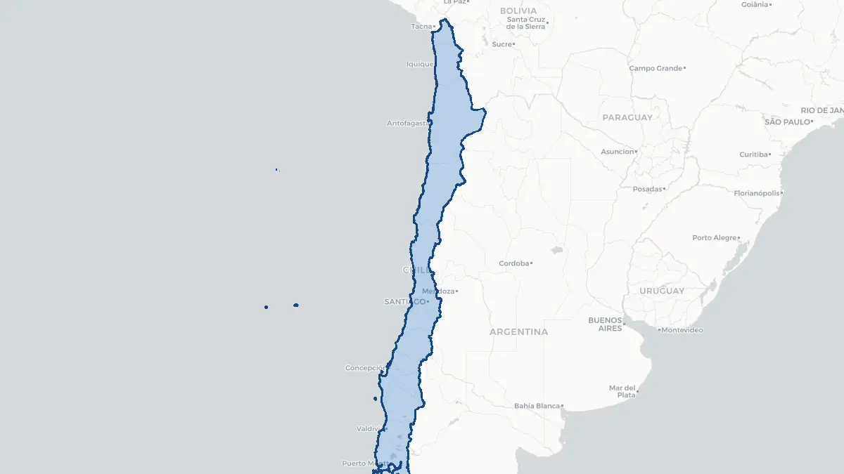
Here you find a map of Chile, capital Santiago, currency Peso and quick links to more facts about the country in South America.
About the country
Chile on the map
About Chile
Chile is a long, narrow country running along the western edge of South America, stretching approximately 4,300 kilometres from north to south while averaging only 177 kilometres in width. It is bordered by Peru to the north, Bolivia to the northeast, Argentina to the east, and the Pacific Ocean to the west. With a population of roughly 19 million people and an area of 756,102 square kilometres, Chile ranks among the most prosperous and stable nations in Latin America. The capital and largest city is Santiago, home to nearly a third of the national population. Chile is a unitary presidential republic. It has consistently high rankings in Latin America for press freedom, human development, and economic competitiveness. The economy is driven by copper mining — Chile holds the world's largest copper reserves — along with agriculture, forestry, fishing, and a growing services sector. Spanish is the official language. Chile also administers Easter Island (Rapa Nui) in the Pacific Ocean and the Juan Fernández Archipelago.
Geography and Landscape
Chile's extraordinary geography is shaped by its slender shape and position along the Pacific Ring of Fire. The Andes Mountains form the eastern border for almost the entire length of the country, with Ojos del Salado at 6,893 metres being the world's highest volcano and Chile's highest peak. The Atacama Desert in the north is the driest non-polar desert on Earth, receiving virtually no rainfall. Central Chile, around Santiago and the Maule region, has a Mediterranean climate ideal for agriculture and wine production. The Lake District in the south, centred on cities such as Temuco, Villarrica, and Puerto Montt, features a landscape of volcanoes, glacial lakes, and dense temperate rainforest. Patagonia and Tierra del Fuego extend further south into sub-Antarctic wilderness. Chilean Patagonia includes Torres del Paine National Park and the Northern and Southern Patagonian Ice Fields, the largest ice masses outside the polar regions. The coastline runs for approximately 6,435 kilometres along the Pacific.
History
The territory of modern Chile was inhabited by various indigenous peoples, including the Mapuche, Aymara, and Atacameño communities, for thousands of years before European contact. The northern regions were incorporated into the Inca Empire in the fifteenth century. Spanish explorer Diego de Almagro led the first European expedition into Chile in 1536, followed by Pedro de Valdivia, who founded Santiago in 1541. The Mapuche people in the south resisted Spanish colonisation in a prolonged conflict known as the Arauco War, which lasted in various forms for over three centuries. Chile declared independence on 18 September 1810, and full independence was achieved under Bernardo O'Higgins and the military support of José de San Martín by 1818. The War of the Pacific (1879–1884) against Bolivia and Peru expanded Chilean territory northward. The twentieth century saw political upheaval culminating in the 1973 military coup led by General Augusto Pinochet, who ruled until 1990. Democratic governance was restored in 1990, and Chile has since developed as a modern, stable democracy.
Geo Quiz
Think you know your capitals, flags, and continents? Take the quiz!
Neighbouring countries
Continue to nearby countries
More countries in the same part of the world
South America index
Open the continent hub for South America to see the full country list, capitals and frequently asked questions on one page.
Interactive map
Zoomable map of Chile
Country index
All countries by continent
Jump directly to the right section or keep scrolling.
Africa
58 countries- Algeria
- Angola
- Benin
- Botswana
- Burkina Faso
- Burundi
- Central African Republic
- Djibouti
- Democratic Republic of the Congo
- Egypt
- Equatorial Guinea
- Ivory Coast
- Eritrea
- Ethiopia
- Gabon
- Gambia
- Ghana
- Guinea
- Guinea-Bissau
- Cameroon
- Cape Verde
- Kenya
- Comoros
- Republic of the Congo
- Lesotho
- Liberia
- Libya
- Madagascar
- Malawi
- Mali
- Morocco
- Mauritania
- Mauritius
- Mayotte
- Mozambique
- Namibia
- Niger
- Nigeria
- Reunion
- Rwanda
- Saint Helena
- Sao Tome and Principe
- Senegal
- Seychelles
- Sierra Leone
- Somalia
- Sudan
- Swaziland
- South Africa
- South Sudan
- Tanzania
- Chad
- Togo
- Tunisia
- Uganda
- Western Sahara
- Zambia
- Zimbabwe
Asia
52 countries- Afghanistan
- Armenia
- Azerbaijan
- Bahrain
- Bangladesh
- Bhutan
- British Indian Ocean Territory
- Brunei
- Myanmar
- Philippines
- United Arab Emirates
- Georgia
- Hong Kong
- India
- Indonesia
- Iraq
- Iran
- Israel
- Japan
- Yemen
- Jordan
- Christmas Island
- Cambodia
- Kazakhstan
- China
- Kyrgyzstan
- Cocos Islands
- Kuwait
- Laos
- Lebanon
- Macau
- Malaysia
- Maldives
- Mongolia
- Nepal
- North Korea
- Oman
- Pakistan
- Palestinian Territory
- Qatar
- Saudi Arabia
- Singapore
- Sri Lanka
- South Korea
- Syria
- Tajikistan
- Taiwan
- Thailand
- Turkey
- Turkmenistan
- Uzbekistan
- Vietnam
Europe
53 countries- Albania
- Andorra
- Belgium
- Bosnia and Herzegovina
- Bulgaria
- Cyprus
- Denmark
- Estonia
- Finland
- France
- Faroe Islands
- Gibraltar
- Greece
- Guernsey
- Ireland
- Iceland
- Isle of Man
- Italy
- Jersey
- Kosovo
- Croatia
- Latvia
- Liechtenstein
- Lithuania
- Luxembourg
- Macedonia
- Malta
- Moldova
- Monaco
- Montenegro
- Netherlands
- Norway
- Poland
- Portugal
- Romania
- Russia
- San Marino
- Switzerland
- Serbia
- Slovakia
- Slovenia
- Spain
- United Kingdom
- Svalbard and Jan Mayen
- Sweden
- Czech Republic
- Germany
- Ukraine
- Hungary
- Vatican
- Belarus
- Aland Islands
- Austria
North America
42 countries- U.S. Virgin Islands
- Anguilla
- Antigua and Barbuda
- Aruba
- Bahamas
- Barbados
- Belize
- Bermuda
- Bonaire, Saint Eustatius and Saba
- British Virgin Islands
- Cayman Islands
- Costa Rica
- Curacao
- Dominica
- Dominican Republic
- El Salvador
- Grenada
- Greenland
- Guadeloupe
- Guatemala
- Haiti
- Honduras
- Jamaica
- Canada
- Cuba
- Martinique
- Mexico
- Montserrat
- Netherlands Antilles
- Nicaragua
- Panama
- Puerto Rico
- Saint Barthelemy
- Saint Kitts and Nevis
- Saint Lucia
- Saint Martin
- Saint Vincent and the Grenadines
- Saint Pierre and Miquelon
- Sint Maarten
- Trinidad and Tobago
- Turks and Caicos Islands
- United States
South America
14 countriesOceania
27 countries- American Samoa
- Australia
- Cook Islands
- Fiji
- French Polynesia
- United States Minor Outlying Islands
- Guam
- Kiribati
- Marshall Islands
- Micronesia
- Nauru
- Niue
- Northern Mariana Islands
- Norfolk Island
- New Caledonia
- New Zealand
- Palau
- Papua New Guinea
- Pitcairn
- Solomon Islands
- Samoa
- Tokelau
- Tonga
- Tuvalu
- Vanuatu
- Wallis and Futuna
- East Timor