
Europe
Serbia — map and facts
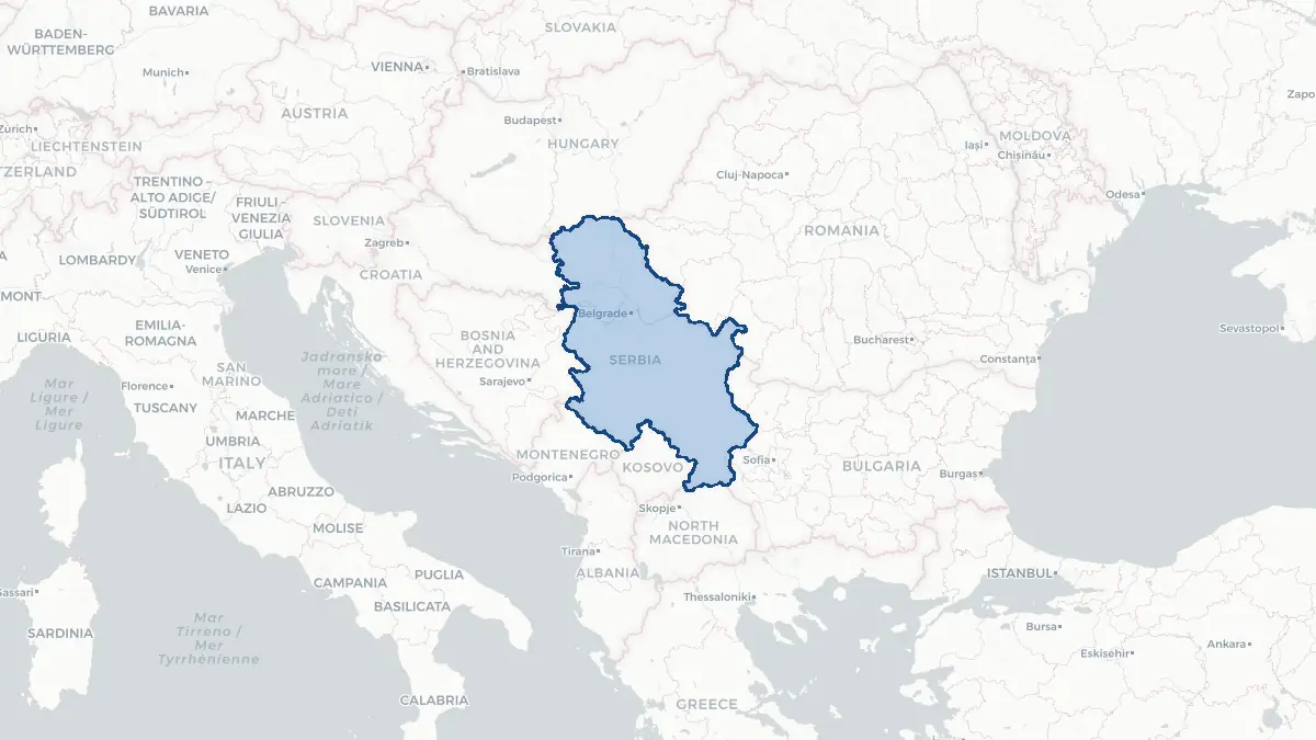
Here you find a map of Serbia, capital Belgrade, currency Dinar and quick links to more facts about the country in Europe.
About the country
Serbia on the map
About Serbia
Serbia is a landlocked country in the central Balkans with approximately 6.8 million people, bordered by Hungary, Romania, Bulgaria, North Macedonia, Kosovo, Montenegro, Bosnia and Herzegovina, and Croatia. Its capital and largest city is Belgrade, situated at the confluence of the Sava and Danube rivers — a strategic crossroads that has made it one of Europe's most historically contested cities. Serbia is an EU candidate country. It declared independence from the State of Serbia and Montenegro in 2006. The status of Kosovo, which declared independence in 2008 and is not recognised by Serbia, remains a key point of tension. Serbian is the official language, using both Cyrillic and Latin scripts. The economy includes manufacturing, agriculture, energy, and a growing IT sector.
Geography and Landscape
Serbia divides broadly into the northern province of Vojvodina — a flat, fertile agricultural plain traversed by the Danube, Tisa, and Sava rivers — and the more mountainous south and east, where the Dinaric Alps, Rhodope spurs, and Carpathian ranges dominate. The highest peak is Midžur (2,169 m) on the Bulgarian border. The Danube enters Serbia from Hungary at Bezdan and forms part of the border with Romania before flowing through the spectacular Iron Gates gorge. The Morava valley in the south is the main corridor linking central and southern Serbia. Serbia has a continental climate with hot summers and cold winters; the south has some Mediterranean influence. The country has significant river resources and hydropower, with the ?erdap hydroelectric plant among the largest in Europe.
History
Slavic tribes settled the western Balkans in the seventh century. The medieval Serbian state rose to prominence under the Nemanji? dynasty, reaching its peak as the Serbian Empire under Tsar Stefan Dušan (1331–1355), which extended across much of the Balkans. The Battle of Kosovo (1389) against the Ottomans became a defining moment of Serbian national identity despite defeat. Serbia fell fully under Ottoman rule by 1459 and remained so for nearly four centuries. The First (1804) and Second Serbian Uprisings (1815) led to autonomy and eventually independence, internationally recognised at the Congress of Berlin in 1878. Serbia fought in both Balkan Wars and both World Wars, suffering devastating losses. After 1945 it became the dominant republic of socialist Yugoslavia. Following Yugoslavia's dissolution in the 1990s and the NATO bombing campaign in 1999 over Kosovo, Serbia re-emerged as an independent state in 2006.
Geo Quiz
Think you know your capitals, flags, and continents? Take the quiz!
Neighbouring countries
Continue to nearby countries
More countries in the same part of the world
Europe index
Open the continent hub for Europe to see the full country list, capitals and frequently asked questions on one page.
Interactive map
Zoomable map of Serbia
Country index
All countries by continent
Jump directly to the right section or keep scrolling.
Africa
58 countries- Algeria
- Angola
- Benin
- Botswana
- Burkina Faso
- Burundi
- Central African Republic
- Djibouti
- Democratic Republic of the Congo
- Egypt
- Equatorial Guinea
- Ivory Coast
- Eritrea
- Ethiopia
- Gabon
- Gambia
- Ghana
- Guinea
- Guinea-Bissau
- Cameroon
- Cape Verde
- Kenya
- Comoros
- Republic of the Congo
- Lesotho
- Liberia
- Libya
- Madagascar
- Malawi
- Mali
- Morocco
- Mauritania
- Mauritius
- Mayotte
- Mozambique
- Namibia
- Niger
- Nigeria
- Reunion
- Rwanda
- Saint Helena
- Sao Tome and Principe
- Senegal
- Seychelles
- Sierra Leone
- Somalia
- Sudan
- Swaziland
- South Africa
- South Sudan
- Tanzania
- Chad
- Togo
- Tunisia
- Uganda
- Western Sahara
- Zambia
- Zimbabwe
Asia
52 countries- Afghanistan
- Armenia
- Azerbaijan
- Bahrain
- Bangladesh
- Bhutan
- British Indian Ocean Territory
- Brunei
- Myanmar
- Philippines
- United Arab Emirates
- Georgia
- Hong Kong
- India
- Indonesia
- Iraq
- Iran
- Israel
- Japan
- Yemen
- Jordan
- Christmas Island
- Cambodia
- Kazakhstan
- China
- Kyrgyzstan
- Cocos Islands
- Kuwait
- Laos
- Lebanon
- Macau
- Malaysia
- Maldives
- Mongolia
- Nepal
- North Korea
- Oman
- Pakistan
- Palestinian Territory
- Qatar
- Saudi Arabia
- Singapore
- Sri Lanka
- South Korea
- Syria
- Tajikistan
- Taiwan
- Thailand
- Turkey
- Turkmenistan
- Uzbekistan
- Vietnam
Europe
53 countries- Albania
- Andorra
- Belgium
- Bosnia and Herzegovina
- Bulgaria
- Cyprus
- Denmark
- Estonia
- Finland
- France
- Faroe Islands
- Gibraltar
- Greece
- Guernsey
- Ireland
- Iceland
- Isle of Man
- Italy
- Jersey
- Kosovo
- Croatia
- Latvia
- Liechtenstein
- Lithuania
- Luxembourg
- Macedonia
- Malta
- Moldova
- Monaco
- Montenegro
- Netherlands
- Norway
- Poland
- Portugal
- Romania
- Russia
- San Marino
- Switzerland
- Serbia
- Slovakia
- Slovenia
- Spain
- United Kingdom
- Svalbard and Jan Mayen
- Sweden
- Czech Republic
- Germany
- Ukraine
- Hungary
- Vatican
- Belarus
- Aland Islands
- Austria
North America
42 countries- U.S. Virgin Islands
- Anguilla
- Antigua and Barbuda
- Aruba
- Bahamas
- Barbados
- Belize
- Bermuda
- Bonaire, Saint Eustatius and Saba
- British Virgin Islands
- Cayman Islands
- Costa Rica
- Curacao
- Dominica
- Dominican Republic
- El Salvador
- Grenada
- Greenland
- Guadeloupe
- Guatemala
- Haiti
- Honduras
- Jamaica
- Canada
- Cuba
- Martinique
- Mexico
- Montserrat
- Netherlands Antilles
- Nicaragua
- Panama
- Puerto Rico
- Saint Barthelemy
- Saint Kitts and Nevis
- Saint Lucia
- Saint Martin
- Saint Vincent and the Grenadines
- Saint Pierre and Miquelon
- Sint Maarten
- Trinidad and Tobago
- Turks and Caicos Islands
- United States
South America
14 countriesOceania
27 countries- American Samoa
- Australia
- Cook Islands
- Fiji
- French Polynesia
- United States Minor Outlying Islands
- Guam
- Kiribati
- Marshall Islands
- Micronesia
- Nauru
- Niue
- Northern Mariana Islands
- Norfolk Island
- New Caledonia
- New Zealand
- Palau
- Papua New Guinea
- Pitcairn
- Solomon Islands
- Samoa
- Tokelau
- Tonga
- Tuvalu
- Vanuatu
- Wallis and Futuna
- East Timor