
Europe
Bosnia and Herzegovina — map and facts
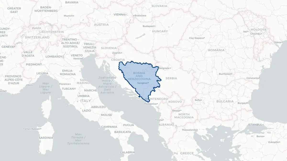
Here you find a map of Bosnia and Herzegovina, capital Sarajevo, currency Marka and quick links to more facts about the country in Europe.
About the country
Bosnia and Herzegovina on the map
About Bosnia and Herzegovina
Bosnia and Herzegovina is a country of approximately 3.5 million people in the western Balkans, bordered by Croatia, Serbia, and Montenegro, with a narrow outlet to the Adriatic Sea. Its capital is Sarajevo, a city renowned for its multicultural heritage and as the site where the assassination of Archduke Franz Ferdinand in 1914 triggered the First World War. The country has a complex federal structure established by the Dayton Agreement of 1995, dividing it into two entities — the Federation of Bosnia and Herzegovina and Republika Srpska — plus the Br?ko District. Three main ethnic groups — Bosniaks, Serbs, and Croats — each have constitutional status and share rotating presidency. Bosnia is an EU candidate and NATO's Partnership for Peace member. The official languages are Bosnian, Croatian, and Serbian — mutually intelligible South Slavic languages. The economy relies on manufacturing, services, and remittances from a large diaspora.
Geography and Landscape
Bosnia and Herzegovina is predominantly mountainous and forested, with the Dinaric Alps running northwest to southeast across the country. Peaks exceed 2,000 metres in the Bjelašnica and Prenj ranges. Major rivers include the Sava (forming the northern border with Croatia), the Bosna, the Neretva, and the Drina. The Neretva cuts a spectacular gorge through the south before reaching the Adriatic near Plo?e. Herzegovina, the southern and western region, has a Mediterranean climate with rocky karst terrain, vineyards, and the city of Mostar, famous for its reconstructed sixteenth-century Ottoman bridge. The interior has a continental climate with cold winters and hot summers. The country is heavily forested — around 50 per cent tree-covered — and has significant hydropower potential. Bosnia's narrow strip of coastline at Neum is its only sea access.
History
The region was settled by Slavic tribes in the seventh century and later became a medieval Bosnian kingdom under Ban Kulin in the twelfth century. Bosnia fell to the Ottoman Empire in 1463 and remained under Ottoman rule for over four centuries, during which many inhabitants converted to Islam. Austria-Hungary annexed Bosnia-Herzegovina in 1908, triggering the diplomatic crisis that preceded the First World War. After 1918 it became part of the Kingdom of Serbs, Croats, and Slovenes, later Yugoslavia. During the Second World War, Bosnia was occupied by Nazi Germany's puppet state and experienced devastating inter-ethnic violence. Bosnia declared independence from Yugoslavia in 1992. The Bosnian War (1992–1995) killed approximately 100,000 people and displaced over two million in Europe's worst conflict since the Second World War. The Dayton Agreement ended the war and established the current constitutional framework.
Geo Quiz
Think you know your capitals, flags, and continents? Take the quiz!
Neighbouring countries
Continue to nearby countries
More countries in the same part of the world
Europe index
Open the continent hub for Europe to see the full country list, capitals and frequently asked questions on one page.
Interactive map
Zoomable map of Bosnia and Herzegovina
Country index
All countries by continent
Jump directly to the right section or keep scrolling.
Africa
58 countries- Algeria
- Angola
- Benin
- Botswana
- Burkina Faso
- Burundi
- Central African Republic
- Djibouti
- Democratic Republic of the Congo
- Egypt
- Equatorial Guinea
- Ivory Coast
- Eritrea
- Ethiopia
- Gabon
- Gambia
- Ghana
- Guinea
- Guinea-Bissau
- Cameroon
- Cape Verde
- Kenya
- Comoros
- Republic of the Congo
- Lesotho
- Liberia
- Libya
- Madagascar
- Malawi
- Mali
- Morocco
- Mauritania
- Mauritius
- Mayotte
- Mozambique
- Namibia
- Niger
- Nigeria
- Reunion
- Rwanda
- Saint Helena
- Sao Tome and Principe
- Senegal
- Seychelles
- Sierra Leone
- Somalia
- Sudan
- Swaziland
- South Africa
- South Sudan
- Tanzania
- Chad
- Togo
- Tunisia
- Uganda
- Western Sahara
- Zambia
- Zimbabwe
Asia
52 countries- Afghanistan
- Armenia
- Azerbaijan
- Bahrain
- Bangladesh
- Bhutan
- British Indian Ocean Territory
- Brunei
- Myanmar
- Philippines
- United Arab Emirates
- Georgia
- Hong Kong
- India
- Indonesia
- Iraq
- Iran
- Israel
- Japan
- Yemen
- Jordan
- Christmas Island
- Cambodia
- Kazakhstan
- China
- Kyrgyzstan
- Cocos Islands
- Kuwait
- Laos
- Lebanon
- Macau
- Malaysia
- Maldives
- Mongolia
- Nepal
- North Korea
- Oman
- Pakistan
- Palestinian Territory
- Qatar
- Saudi Arabia
- Singapore
- Sri Lanka
- South Korea
- Syria
- Tajikistan
- Taiwan
- Thailand
- Turkey
- Turkmenistan
- Uzbekistan
- Vietnam
Europe
53 countries- Albania
- Andorra
- Belgium
- Bosnia and Herzegovina
- Bulgaria
- Cyprus
- Denmark
- Estonia
- Finland
- France
- Faroe Islands
- Gibraltar
- Greece
- Guernsey
- Ireland
- Iceland
- Isle of Man
- Italy
- Jersey
- Kosovo
- Croatia
- Latvia
- Liechtenstein
- Lithuania
- Luxembourg
- Macedonia
- Malta
- Moldova
- Monaco
- Montenegro
- Netherlands
- Norway
- Poland
- Portugal
- Romania
- Russia
- San Marino
- Switzerland
- Serbia
- Slovakia
- Slovenia
- Spain
- United Kingdom
- Svalbard and Jan Mayen
- Sweden
- Czech Republic
- Germany
- Ukraine
- Hungary
- Vatican
- Belarus
- Aland Islands
- Austria
North America
42 countries- U.S. Virgin Islands
- Anguilla
- Antigua and Barbuda
- Aruba
- Bahamas
- Barbados
- Belize
- Bermuda
- Bonaire, Saint Eustatius and Saba
- British Virgin Islands
- Cayman Islands
- Costa Rica
- Curacao
- Dominica
- Dominican Republic
- El Salvador
- Grenada
- Greenland
- Guadeloupe
- Guatemala
- Haiti
- Honduras
- Jamaica
- Canada
- Cuba
- Martinique
- Mexico
- Montserrat
- Netherlands Antilles
- Nicaragua
- Panama
- Puerto Rico
- Saint Barthelemy
- Saint Kitts and Nevis
- Saint Lucia
- Saint Martin
- Saint Vincent and the Grenadines
- Saint Pierre and Miquelon
- Sint Maarten
- Trinidad and Tobago
- Turks and Caicos Islands
- United States
South America
14 countriesOceania
27 countries- American Samoa
- Australia
- Cook Islands
- Fiji
- French Polynesia
- United States Minor Outlying Islands
- Guam
- Kiribati
- Marshall Islands
- Micronesia
- Nauru
- Niue
- Northern Mariana Islands
- Norfolk Island
- New Caledonia
- New Zealand
- Palau
- Papua New Guinea
- Pitcairn
- Solomon Islands
- Samoa
- Tokelau
- Tonga
- Tuvalu
- Vanuatu
- Wallis and Futuna
- East Timor