
Africa
Lesotho — map and facts
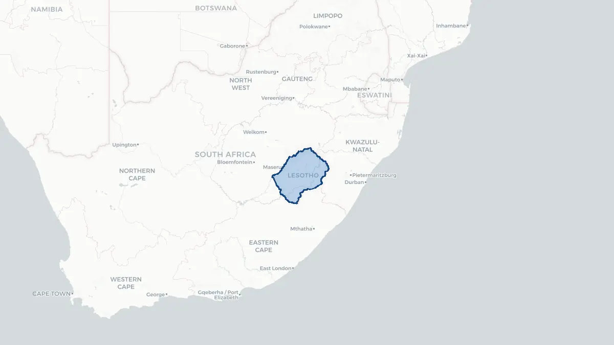
Here you find a map of Lesotho, capital Maseru, currency Loti Rand and quick links to more facts about the country in Africa.
About the country
Lesotho on the map
About Lesotho
Lesotho is a small, landlocked kingdom entirely surrounded by South Africa, making it one of only three countries in the world completely enclosed within another nation. Its capital and largest city is Maseru. The country has a population of approximately 2.2 million people and is a constitutional monarchy, with King Letsie III serving as head of state. The official languages are Sesotho and English. Lesotho is classified as a lower-middle-income country and faces significant economic and social challenges, including high rates of HIV/AIDS prevalence among the highest in the world, widespread unemployment, and heavy economic dependence on South Africa. Many Basotho men have historically worked in South African mines. Lesotho's economy benefits from membership in the Southern African Customs Union and from the Lesotho Highlands Water Project, which exports water to water-scarce South Africa in exchange for royalties that provide a significant portion of government revenue.
Geography and Landscape
Lesotho is remarkable for being the only country in the world situated entirely above 1,000 metres in elevation, earning it the nickname "the Kingdom in the Sky." The terrain is dominated by high mountain ranges and deeply incised river valleys. The Maluti Mountains in the west and the Drakensberg range along the eastern border contain some of southern Africa's highest peaks, with Thabana Ntlenyana rising to 3,482 metres as the continent's highest point south of Kilimanjaro. The Orange River, known locally as the Senqu, rises in the highlands of Lesotho and flows westward into South Africa. The western lowlands, though relatively narrow, constitute the most densely populated and agriculturally productive zone. The climate is alpine, with cold winters that bring significant snowfall to the highlands, warm summers, and frequent mist. The Lesotho Highlands Water Project has created several large reservoirs, most notably Katse Dam, reshaping the landscape.
History
The Basotho nation was founded in the early 19th century by Moshoeshoe I, a visionary leader who united various displaced clans fleeing the Mfecane, a period of widespread warfare across southern Africa triggered by Zulu expansion. Moshoeshoe established his stronghold at Thaba Bosiu, a flat-topped mountain considered nearly impregnable. He successfully resisted Zulu, Ndebele, and Boer incursions and, facing increasing pressure from Boer settlers, sought British protection in 1868, making Basutoland a British protectorate. The territory avoided incorporation into the Union of South Africa in 1910, remaining under direct British administration. It achieved independence on 4 October 1966, becoming the Kingdom of Lesotho under King Moshoeshoe II. Post-independence politics have been turbulent, marked by coups, military rule, and political crises, though Lesotho has maintained its sovereignty and national identity as a distinct cultural and political entity surrounded entirely by its more powerful neighbour.
Geo Quiz
Think you know your capitals, flags, and continents? Take the quiz!
Neighbouring countries
Continue to nearby countries
More countries in the same part of the world
Africa index
Open the continent hub for Africa to see the full country list, capitals and frequently asked questions on one page.
Interactive map
Zoomable map of Lesotho
Country index
All countries by continent
Jump directly to the right section or keep scrolling.
Africa
58 countries- Algeria
- Angola
- Benin
- Botswana
- Burkina Faso
- Burundi
- Central African Republic
- Djibouti
- Democratic Republic of the Congo
- Egypt
- Equatorial Guinea
- Ivory Coast
- Eritrea
- Ethiopia
- Gabon
- Gambia
- Ghana
- Guinea
- Guinea-Bissau
- Cameroon
- Cape Verde
- Kenya
- Comoros
- Republic of the Congo
- Lesotho
- Liberia
- Libya
- Madagascar
- Malawi
- Mali
- Morocco
- Mauritania
- Mauritius
- Mayotte
- Mozambique
- Namibia
- Niger
- Nigeria
- Reunion
- Rwanda
- Saint Helena
- Sao Tome and Principe
- Senegal
- Seychelles
- Sierra Leone
- Somalia
- Sudan
- Swaziland
- South Africa
- South Sudan
- Tanzania
- Chad
- Togo
- Tunisia
- Uganda
- Western Sahara
- Zambia
- Zimbabwe
Asia
52 countries- Afghanistan
- Armenia
- Azerbaijan
- Bahrain
- Bangladesh
- Bhutan
- British Indian Ocean Territory
- Brunei
- Myanmar
- Philippines
- United Arab Emirates
- Georgia
- Hong Kong
- India
- Indonesia
- Iraq
- Iran
- Israel
- Japan
- Yemen
- Jordan
- Christmas Island
- Cambodia
- Kazakhstan
- China
- Kyrgyzstan
- Cocos Islands
- Kuwait
- Laos
- Lebanon
- Macau
- Malaysia
- Maldives
- Mongolia
- Nepal
- North Korea
- Oman
- Pakistan
- Palestinian Territory
- Qatar
- Saudi Arabia
- Singapore
- Sri Lanka
- South Korea
- Syria
- Tajikistan
- Taiwan
- Thailand
- Turkey
- Turkmenistan
- Uzbekistan
- Vietnam
Europe
53 countries- Albania
- Andorra
- Belgium
- Bosnia and Herzegovina
- Bulgaria
- Cyprus
- Denmark
- Estonia
- Finland
- France
- Faroe Islands
- Gibraltar
- Greece
- Guernsey
- Ireland
- Iceland
- Isle of Man
- Italy
- Jersey
- Kosovo
- Croatia
- Latvia
- Liechtenstein
- Lithuania
- Luxembourg
- Macedonia
- Malta
- Moldova
- Monaco
- Montenegro
- Netherlands
- Norway
- Poland
- Portugal
- Romania
- Russia
- San Marino
- Switzerland
- Serbia
- Slovakia
- Slovenia
- Spain
- United Kingdom
- Svalbard and Jan Mayen
- Sweden
- Czech Republic
- Germany
- Ukraine
- Hungary
- Vatican
- Belarus
- Aland Islands
- Austria
North America
42 countries- U.S. Virgin Islands
- Anguilla
- Antigua and Barbuda
- Aruba
- Bahamas
- Barbados
- Belize
- Bermuda
- Bonaire, Saint Eustatius and Saba
- British Virgin Islands
- Cayman Islands
- Costa Rica
- Curacao
- Dominica
- Dominican Republic
- El Salvador
- Grenada
- Greenland
- Guadeloupe
- Guatemala
- Haiti
- Honduras
- Jamaica
- Canada
- Cuba
- Martinique
- Mexico
- Montserrat
- Netherlands Antilles
- Nicaragua
- Panama
- Puerto Rico
- Saint Barthelemy
- Saint Kitts and Nevis
- Saint Lucia
- Saint Martin
- Saint Vincent and the Grenadines
- Saint Pierre and Miquelon
- Sint Maarten
- Trinidad and Tobago
- Turks and Caicos Islands
- United States
South America
14 countriesOceania
27 countries- American Samoa
- Australia
- Cook Islands
- Fiji
- French Polynesia
- United States Minor Outlying Islands
- Guam
- Kiribati
- Marshall Islands
- Micronesia
- Nauru
- Niue
- Northern Mariana Islands
- Norfolk Island
- New Caledonia
- New Zealand
- Palau
- Papua New Guinea
- Pitcairn
- Solomon Islands
- Samoa
- Tokelau
- Tonga
- Tuvalu
- Vanuatu
- Wallis and Futuna
- East Timor