
Europe
Macedonia — map and facts
Here you find a map of Macedonia, capital Skopje, currency Denar and quick links to more facts about the country in Europe.
About the country
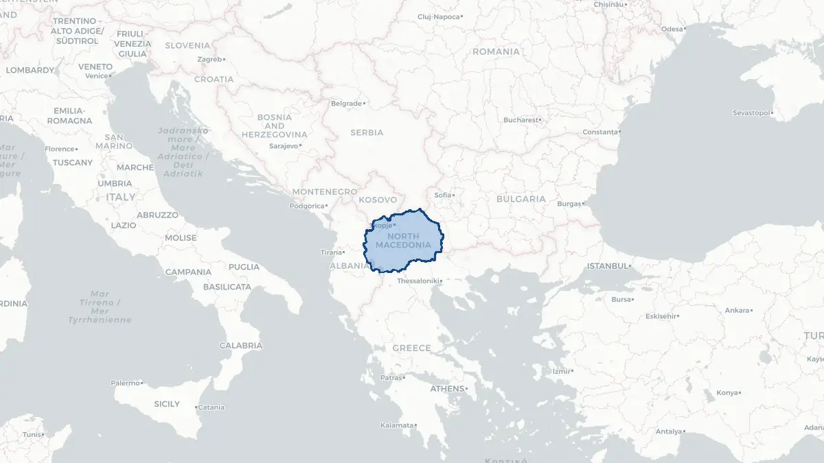
Macedonia on the map
About North Macedonia
North Macedonia is a landlocked country in the south-central Balkans of approximately 2 million people, bordered by Kosovo, Serbia, Bulgaria, Greece, and Albania. Its capital is Skopje. The country declared independence from Yugoslavia in 1991 and joined NATO in 2020. It is an EU candidate. The country's name was officially changed from "Macedonia" to "North Macedonia" in 2019 under the Prespa Agreement with Greece, which had objected to the original name as implying claims over its own northern region of Macedonia. The official language is Macedonian, a South Slavic language, and Albanian is also an official language in areas with Albanian majorities. The economy relies on small-scale manufacturing, agriculture, and services; remittances are significant.
Geography and Landscape
North Macedonia is characterised by a basin structure of high mountains surrounding broad river valleys and lakes. The Vardar River, the country's principal waterway, flows southward through the country before entering Greece and reaching the Aegean Sea. The Šar Mountains in the northwest and the Jakupica range in the centre exceed 2,700 metres. Lake Ohrid in the southwest is one of Europe's deepest and oldest lakes — estimated to be over three million years old — and is a UNESCO World Heritage Site for both its natural and cultural significance. Lake Prespa is shared among North Macedonia, Greece, and Albania. The climate is continental in the interior and Mediterranean-influenced in the south and southwest around Ohrid.
History
The territory of modern North Macedonia has been inhabited since prehistoric times. Ancient Macedonia, the kingdom of Philip II and Alexander the Great, extended across the broader region. After Roman, Byzantine, and Bulgarian rule, the medieval Serbian Empire expanded here in the fourteenth century before Ottoman conquest in 1395 — under which the region remained for five centuries. The Ilinden Uprising of 1903 was a landmark event in Macedonian national consciousness. After the Balkan Wars (1912–1913), the territory was divided between Serbia, Greece, and Bulgaria. The region became part of Yugoslavia in 1918 and the Socialist Republic of Macedonia within the Yugoslav federation in 1944. North Macedonia declared independence in 1991, joined the UN in 1993, and NATO in 2020.
Geo Quiz
Think you know your capitals, flags, and continents? Take the quiz!
Neighbouring countries
Continue to nearby countries
More countries in the same part of the world
Europe index
Open the continent hub for Europe to see the full country list, capitals and frequently asked questions on one page.
Interactive map
Zoomable map of Macedonia
Country index
All countries by continent
Jump directly to the right section or keep scrolling.
Africa
58 countries- Algeria
- Angola
- Benin
- Botswana
- Burkina Faso
- Burundi
- Central African Republic
- Djibouti
- Democratic Republic of the Congo
- Egypt
- Equatorial Guinea
- Ivory Coast
- Eritrea
- Ethiopia
- Gabon
- Gambia
- Ghana
- Guinea
- Guinea-Bissau
- Cameroon
- Cape Verde
- Kenya
- Comoros
- Republic of the Congo
- Lesotho
- Liberia
- Libya
- Madagascar
- Malawi
- Mali
- Morocco
- Mauritania
- Mauritius
- Mayotte
- Mozambique
- Namibia
- Niger
- Nigeria
- Reunion
- Rwanda
- Saint Helena
- Sao Tome and Principe
- Senegal
- Seychelles
- Sierra Leone
- Somalia
- Sudan
- Swaziland
- South Africa
- South Sudan
- Tanzania
- Chad
- Togo
- Tunisia
- Uganda
- Western Sahara
- Zambia
- Zimbabwe
Asia
52 countries- Afghanistan
- Armenia
- Azerbaijan
- Bahrain
- Bangladesh
- Bhutan
- British Indian Ocean Territory
- Brunei
- Myanmar
- Philippines
- United Arab Emirates
- Georgia
- Hong Kong
- India
- Indonesia
- Iraq
- Iran
- Israel
- Japan
- Yemen
- Jordan
- Christmas Island
- Cambodia
- Kazakhstan
- China
- Kyrgyzstan
- Cocos Islands
- Kuwait
- Laos
- Lebanon
- Macau
- Malaysia
- Maldives
- Mongolia
- Nepal
- North Korea
- Oman
- Pakistan
- Palestinian Territory
- Qatar
- Saudi Arabia
- Singapore
- Sri Lanka
- South Korea
- Syria
- Tajikistan
- Taiwan
- Thailand
- Turkey
- Turkmenistan
- Uzbekistan
- Vietnam
Europe
53 countries- Albania
- Andorra
- Belgium
- Bosnia and Herzegovina
- Bulgaria
- Cyprus
- Denmark
- Estonia
- Finland
- France
- Faroe Islands
- Gibraltar
- Greece
- Guernsey
- Ireland
- Iceland
- Isle of Man
- Italy
- Jersey
- Kosovo
- Croatia
- Latvia
- Liechtenstein
- Lithuania
- Luxembourg
- Macedonia
- Malta
- Moldova
- Monaco
- Montenegro
- Netherlands
- Norway
- Poland
- Portugal
- Romania
- Russia
- San Marino
- Switzerland
- Serbia
- Slovakia
- Slovenia
- Spain
- United Kingdom
- Svalbard and Jan Mayen
- Sweden
- Czech Republic
- Germany
- Ukraine
- Hungary
- Vatican
- Belarus
- Aland Islands
- Austria
North America
42 countries- U.S. Virgin Islands
- Anguilla
- Antigua and Barbuda
- Aruba
- Bahamas
- Barbados
- Belize
- Bermuda
- Bonaire, Saint Eustatius and Saba
- British Virgin Islands
- Cayman Islands
- Costa Rica
- Curacao
- Dominica
- Dominican Republic
- El Salvador
- Grenada
- Greenland
- Guadeloupe
- Guatemala
- Haiti
- Honduras
- Jamaica
- Canada
- Cuba
- Martinique
- Mexico
- Montserrat
- Netherlands Antilles
- Nicaragua
- Panama
- Puerto Rico
- Saint Barthelemy
- Saint Kitts and Nevis
- Saint Lucia
- Saint Martin
- Saint Vincent and the Grenadines
- Saint Pierre and Miquelon
- Sint Maarten
- Trinidad and Tobago
- Turks and Caicos Islands
- United States
South America
14 countriesOceania
27 countries- American Samoa
- Australia
- Cook Islands
- Fiji
- French Polynesia
- United States Minor Outlying Islands
- Guam
- Kiribati
- Marshall Islands
- Micronesia
- Nauru
- Niue
- Northern Mariana Islands
- Norfolk Island
- New Caledonia
- New Zealand
- Palau
- Papua New Guinea
- Pitcairn
- Solomon Islands
- Samoa
- Tokelau
- Tonga
- Tuvalu
- Vanuatu
- Wallis and Futuna
- East Timor