
Europe
Lithuania — map and facts
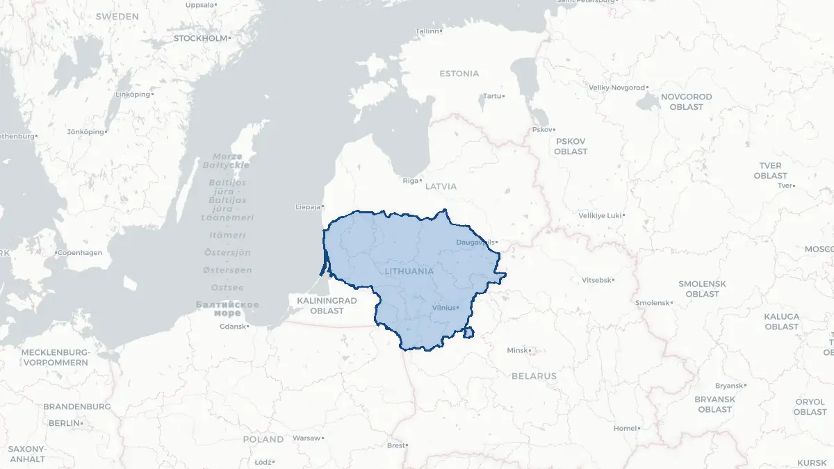
Here you find a map of Lithuania, capital Vilnius, currency Euro and quick links to more facts about the country in Europe.
About the country
Lithuania on the map
About Lithuania
Lithuania is the largest and most populous of the three Baltic states, with approximately 2.8 million people, bordering Latvia, Belarus, Poland, and the Russian exclave of Kaliningrad. Its capital is Vilnius, a Baroque city whose historic centre is a UNESCO World Heritage Site. Lithuania is a parliamentary republic, NATO and EU member since 2004, and adopted the euro in 2015. Lithuanian is the official language — an ancient Indo-European language considered the most archaic living language in the family. Lithuania has a complex history as the medieval Grand Duchy of Lithuania was once the largest state in Europe. The country has a strong IT and technology sector, significant manufacturing, and a growing startup ecosystem. Lithuania has also been at the forefront of European responses to Russian aggression in Ukraine, deploying significant military resources to NATO's eastern flank.
Geography and Landscape
Lithuania occupies a rolling plains landscape, heavily forested (around 35 per cent of the territory), with numerous lakes — over 2,800 — rivers, and wetlands. The highest point is Aukštojas Hill at just 294 metres. The Nemunas is the principal river, flowing westward across the country before reaching the Curonian Lagoon and the Baltic Sea. The Curonian Spit — a UNESCO World Heritage Site shared with Russia — is a remarkable sandy peninsula separating the lagoon from the open sea. Lithuania's Baltic coast, the Samogitian Highlands in the northwest, and the lake districts in the east are the main landscape zones. The climate is temperate continental, with warm summers and cold winters; snowfall is common from December to March.
History
Lithuania has a history stretching back to Baltic tribal societies, but rose to prominence with the Grand Duchy of Lithuania, established in the thirteenth century. Under Grand Duke Gediminas and later Vytautas the Great, the duchy expanded to cover much of Eastern Europe, from the Baltic to the Black Sea. The 1569 Union of Lublin created the Polish-Lithuanian Commonwealth. The three partitions of Poland (1772, 1793, 1795) wiped Lithuania from the map. Lithuania declared independence on 16 February 1918. Soviet occupation followed in 1940, German occupation 1941–1944, then Soviet rule until 1990. Lithuania was the first Soviet republic to declare the restoration of independence on 11 March 1990; formal Soviet recognition came in 1991 after the failed August coup. Lithuania joined NATO and the EU in 2004.
Geo Quiz
Think you know your capitals, flags, and continents? Take the quiz!
Neighbouring countries
Continue to nearby countries
More countries in the same part of the world
Europe index
Open the continent hub for Europe to see the full country list, capitals and frequently asked questions on one page.
Interactive map
Zoomable map of Lithuania
Country index
All countries by continent
Jump directly to the right section or keep scrolling.
Africa
58 countries- Algeria
- Angola
- Benin
- Botswana
- Burkina Faso
- Burundi
- Central African Republic
- Djibouti
- Democratic Republic of the Congo
- Egypt
- Equatorial Guinea
- Ivory Coast
- Eritrea
- Ethiopia
- Gabon
- Gambia
- Ghana
- Guinea
- Guinea-Bissau
- Cameroon
- Cape Verde
- Kenya
- Comoros
- Republic of the Congo
- Lesotho
- Liberia
- Libya
- Madagascar
- Malawi
- Mali
- Morocco
- Mauritania
- Mauritius
- Mayotte
- Mozambique
- Namibia
- Niger
- Nigeria
- Reunion
- Rwanda
- Saint Helena
- Sao Tome and Principe
- Senegal
- Seychelles
- Sierra Leone
- Somalia
- Sudan
- Swaziland
- South Africa
- South Sudan
- Tanzania
- Chad
- Togo
- Tunisia
- Uganda
- Western Sahara
- Zambia
- Zimbabwe
Asia
52 countries- Afghanistan
- Armenia
- Azerbaijan
- Bahrain
- Bangladesh
- Bhutan
- British Indian Ocean Territory
- Brunei
- Myanmar
- Philippines
- United Arab Emirates
- Georgia
- Hong Kong
- India
- Indonesia
- Iraq
- Iran
- Israel
- Japan
- Yemen
- Jordan
- Christmas Island
- Cambodia
- Kazakhstan
- China
- Kyrgyzstan
- Cocos Islands
- Kuwait
- Laos
- Lebanon
- Macau
- Malaysia
- Maldives
- Mongolia
- Nepal
- North Korea
- Oman
- Pakistan
- Palestinian Territory
- Qatar
- Saudi Arabia
- Singapore
- Sri Lanka
- South Korea
- Syria
- Tajikistan
- Taiwan
- Thailand
- Turkey
- Turkmenistan
- Uzbekistan
- Vietnam
Europe
53 countries- Albania
- Andorra
- Belgium
- Bosnia and Herzegovina
- Bulgaria
- Cyprus
- Denmark
- Estonia
- Finland
- France
- Faroe Islands
- Gibraltar
- Greece
- Guernsey
- Ireland
- Iceland
- Isle of Man
- Italy
- Jersey
- Kosovo
- Croatia
- Latvia
- Liechtenstein
- Lithuania
- Luxembourg
- Macedonia
- Malta
- Moldova
- Monaco
- Montenegro
- Netherlands
- Norway
- Poland
- Portugal
- Romania
- Russia
- San Marino
- Switzerland
- Serbia
- Slovakia
- Slovenia
- Spain
- United Kingdom
- Svalbard and Jan Mayen
- Sweden
- Czech Republic
- Germany
- Ukraine
- Hungary
- Vatican
- Belarus
- Aland Islands
- Austria
North America
42 countries- U.S. Virgin Islands
- Anguilla
- Antigua and Barbuda
- Aruba
- Bahamas
- Barbados
- Belize
- Bermuda
- Bonaire, Saint Eustatius and Saba
- British Virgin Islands
- Cayman Islands
- Costa Rica
- Curacao
- Dominica
- Dominican Republic
- El Salvador
- Grenada
- Greenland
- Guadeloupe
- Guatemala
- Haiti
- Honduras
- Jamaica
- Canada
- Cuba
- Martinique
- Mexico
- Montserrat
- Netherlands Antilles
- Nicaragua
- Panama
- Puerto Rico
- Saint Barthelemy
- Saint Kitts and Nevis
- Saint Lucia
- Saint Martin
- Saint Vincent and the Grenadines
- Saint Pierre and Miquelon
- Sint Maarten
- Trinidad and Tobago
- Turks and Caicos Islands
- United States
South America
14 countriesOceania
27 countries- American Samoa
- Australia
- Cook Islands
- Fiji
- French Polynesia
- United States Minor Outlying Islands
- Guam
- Kiribati
- Marshall Islands
- Micronesia
- Nauru
- Niue
- Northern Mariana Islands
- Norfolk Island
- New Caledonia
- New Zealand
- Palau
- Papua New Guinea
- Pitcairn
- Solomon Islands
- Samoa
- Tokelau
- Tonga
- Tuvalu
- Vanuatu
- Wallis and Futuna
- East Timor