
South America
Falkland Islands — map and facts
Here you find a map of Falkland Islands, capital Stanley, currency Falklandspund and quick links to more facts about the country in South America.
About the country
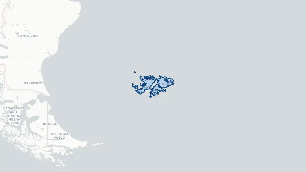
Falkland Islands on the map
About Falkland Islands
The Falkland Islands is a British Overseas Territory situated in the South Atlantic Ocean, approximately 480 kilometres east of the southern tip of South America. The capital is Stanley, on East Falkland, which is home to the majority of the population. The total population is around 3,500 permanent residents, predominantly of British descent. The islands have a significant degree of internal self-governance, with their own elected Legislative Assembly and Executive Council, while the United Kingdom retains responsibility for defence and foreign affairs. Argentina claims sovereignty over the islands, which it calls the Islas Malvinas, and this dispute remains unresolved. The economy is based primarily on fishing licence revenues, sheep farming and wool production, and tourism, with the latter growing significantly due to cruise ship visits. Since the 1990s, oil exploration in surrounding waters has also attracted interest. The currency is the Falkland Islands pound, pegged to pound sterling.
Geography and Landscape
The Falkland Islands consist of two main islands — East Falkland and West Falkland — and approximately 776 smaller islands, giving a total land area of around 12,173 square kilometres. The terrain is largely open, rolling moorland and upland with quartzite stone runs — unusual geological features of shattered rock forming rivers of stone along valley floors. The highest point is Mount Adam on West Falkland at 700 metres. The coastline is deeply indented with numerous bays, inlets, and natural harbours. Vegetation is predominantly tussock grass, dwarf shrubs, and heath, with no native trees. The climate is cool, windy, and changeable, with frequent overcast skies. The islands sit in the South Atlantic and experience subantarctic influences, with cold westerly winds prevailing. The surrounding seas are rich in marine life, supporting large populations of penguins, seals, elephant seals, dolphins, and whales, as well as significant seabird colonies.
History
The Falkland Islands were likely sighted by early European navigators in the sixteenth century. The first recorded landing was by English captain John Strong in 1690. France established a settlement at Port Louis on East Falkland in 1764, followed by a British settlement at Port Egmont on West Falkland in 1765. Spain bought out French claims in 1767 and forcibly expelled the British in 1770, though they returned briefly before abandoning the islands in 1774. Argentina claimed the islands after independence from Spain, but Britain reasserted sovereignty in 1833, expelling Argentine settlers. In April 1982, Argentina invaded and occupied the islands. The United Kingdom responded with a naval task force, and following a ten-week conflict, Argentine forces surrendered on 14 June 1982. This war had profound political consequences in both countries. A 2013 referendum saw 99.8 percent of islanders vote to remain a British Overseas Territory.
Geo Quiz
Think you know your capitals, flags, and continents? Take the quiz!
Neighbouring countries
Continue to nearby countries
There are no registered neighbouring countries for Falkland Islands in the current database.
More countries in the same part of the world
South America index
Open the continent hub for South America to see the full country list, capitals and frequently asked questions on one page.
Interactive map
Zoomable map of Falkland Islands
Country index
All countries by continent
Jump directly to the right section or keep scrolling.
Africa
58 countries- Algeria
- Angola
- Benin
- Botswana
- Burkina Faso
- Burundi
- Central African Republic
- Djibouti
- Democratic Republic of the Congo
- Egypt
- Equatorial Guinea
- Ivory Coast
- Eritrea
- Ethiopia
- Gabon
- Gambia
- Ghana
- Guinea
- Guinea-Bissau
- Cameroon
- Cape Verde
- Kenya
- Comoros
- Republic of the Congo
- Lesotho
- Liberia
- Libya
- Madagascar
- Malawi
- Mali
- Morocco
- Mauritania
- Mauritius
- Mayotte
- Mozambique
- Namibia
- Niger
- Nigeria
- Reunion
- Rwanda
- Saint Helena
- Sao Tome and Principe
- Senegal
- Seychelles
- Sierra Leone
- Somalia
- Sudan
- Swaziland
- South Africa
- South Sudan
- Tanzania
- Chad
- Togo
- Tunisia
- Uganda
- Western Sahara
- Zambia
- Zimbabwe
Asia
52 countries- Afghanistan
- Armenia
- Azerbaijan
- Bahrain
- Bangladesh
- Bhutan
- British Indian Ocean Territory
- Brunei
- Myanmar
- Philippines
- United Arab Emirates
- Georgia
- Hong Kong
- India
- Indonesia
- Iraq
- Iran
- Israel
- Japan
- Yemen
- Jordan
- Christmas Island
- Cambodia
- Kazakhstan
- China
- Kyrgyzstan
- Cocos Islands
- Kuwait
- Laos
- Lebanon
- Macau
- Malaysia
- Maldives
- Mongolia
- Nepal
- North Korea
- Oman
- Pakistan
- Palestinian Territory
- Qatar
- Saudi Arabia
- Singapore
- Sri Lanka
- South Korea
- Syria
- Tajikistan
- Taiwan
- Thailand
- Turkey
- Turkmenistan
- Uzbekistan
- Vietnam
Europe
53 countries- Albania
- Andorra
- Belgium
- Bosnia and Herzegovina
- Bulgaria
- Cyprus
- Denmark
- Estonia
- Finland
- France
- Faroe Islands
- Gibraltar
- Greece
- Guernsey
- Ireland
- Iceland
- Isle of Man
- Italy
- Jersey
- Kosovo
- Croatia
- Latvia
- Liechtenstein
- Lithuania
- Luxembourg
- Macedonia
- Malta
- Moldova
- Monaco
- Montenegro
- Netherlands
- Norway
- Poland
- Portugal
- Romania
- Russia
- San Marino
- Switzerland
- Serbia
- Slovakia
- Slovenia
- Spain
- United Kingdom
- Svalbard and Jan Mayen
- Sweden
- Czech Republic
- Germany
- Ukraine
- Hungary
- Vatican
- Belarus
- Aland Islands
- Austria
North America
42 countries- U.S. Virgin Islands
- Anguilla
- Antigua and Barbuda
- Aruba
- Bahamas
- Barbados
- Belize
- Bermuda
- Bonaire, Saint Eustatius and Saba
- British Virgin Islands
- Cayman Islands
- Costa Rica
- Curacao
- Dominica
- Dominican Republic
- El Salvador
- Grenada
- Greenland
- Guadeloupe
- Guatemala
- Haiti
- Honduras
- Jamaica
- Canada
- Cuba
- Martinique
- Mexico
- Montserrat
- Netherlands Antilles
- Nicaragua
- Panama
- Puerto Rico
- Saint Barthelemy
- Saint Kitts and Nevis
- Saint Lucia
- Saint Martin
- Saint Vincent and the Grenadines
- Saint Pierre and Miquelon
- Sint Maarten
- Trinidad and Tobago
- Turks and Caicos Islands
- United States
South America
14 countriesOceania
27 countries- American Samoa
- Australia
- Cook Islands
- Fiji
- French Polynesia
- United States Minor Outlying Islands
- Guam
- Kiribati
- Marshall Islands
- Micronesia
- Nauru
- Niue
- Northern Mariana Islands
- Norfolk Island
- New Caledonia
- New Zealand
- Palau
- Papua New Guinea
- Pitcairn
- Solomon Islands
- Samoa
- Tokelau
- Tonga
- Tuvalu
- Vanuatu
- Wallis and Futuna
- East Timor