
Africa
Libya — map and facts
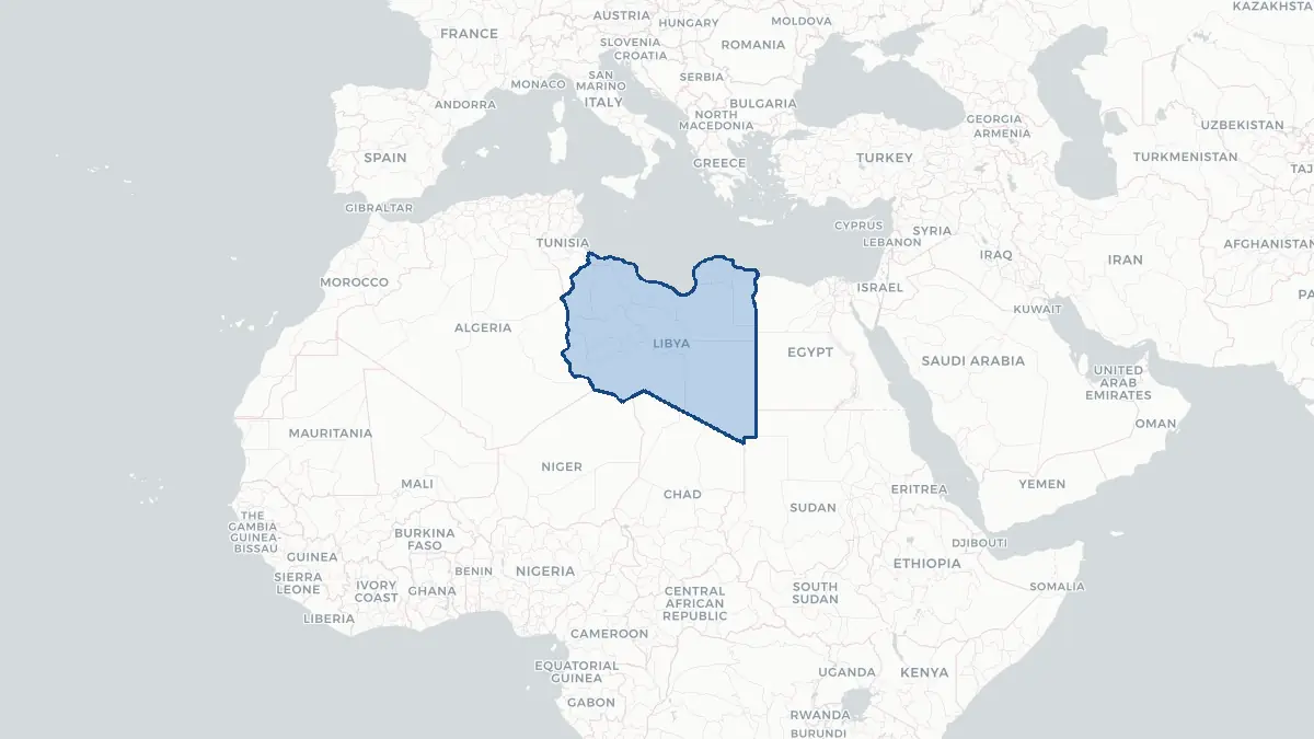
Here you find a map of Libya, capital Tripolis, currency Libysk dinar and quick links to more facts about the country in Africa.
About the country
Libya on the map
About Libya
Libya is a vast North African country with a population of approximately 7 million people. Its capital is Tripoli, located on the Mediterranean coast, though Benghazi serves as the main city of the eastern region. The country is a member of the Arab League and the African Union, and its official language is Arabic. Libya's economy has historically been dominated by petroleum exports, which account for the vast majority of government revenues. Since the fall of Muammar Gaddafi's 42-year rule in 2011, the country has endured prolonged political instability, with rival governments and armed factions contesting control. A Government of National Unity, based in Tripoli, and a competing administration in the east have divided the country into contested spheres of influence. Libya's society is predominantly Muslim and organized along tribal lines, with over 140 recognized tribes playing significant roles in political life. Despite its oil wealth, ongoing conflict has severely disrupted public services and economic development.
Geography and Landscape
Libya is the fourth-largest country in Africa, covering approximately 1.76 million square kilometres. The vast majority of its territory — roughly 90 percent — is occupied by the Sahara Desert, making it one of the most arid countries on Earth. The northern coastal strip, known as Tripolitania in the west and Cyrenaica in the east, contains fertile land and most of the population. The Gulf of Sidra indents the Mediterranean coastline at the country's centre. In the south, the Fezzan region is characterised by ergs, vast sand seas, and rocky plateaus. The Tibesti Mountains extend into southern Libya from Chad, reaching elevations above 2,000 metres. The Nafusa Mountains rise inland from Tripolitania. Libya has no permanent rivers; instead, wadis carry seasonal rainfall. The climate along the coast is Mediterranean, with hot, dry summers and mild winters, while the interior experiences extreme temperature swings between scorching days and cold nights.
History
Libya's recorded history stretches back to ancient times, when Phoenician traders established Carthaginian colonies along the coast around 800 BCE. Greek settlers founded Cyrene in the east around 631 BCE, creating the region of Cyrenaica. Rome later absorbed these territories, and cities such as Leptis Magna, Sabratha, and Oea flourished. Arab armies conquered the region in the 7th century CE, bringing Islam and the Arabic language. Ottoman rule followed from 1551 until Italy seized the territory in 1911–12, establishing Italian Libya. Brutal colonial pacification campaigns, led against resistance fighter Omar Mukhtar, culminated in his execution in 1931. Libya gained independence as a kingdom under King Idris in 1951. Muammar Gaddafi overthrew the monarchy in a 1969 coup and ruled for 42 years, nationalizing oil and pursuing an idiosyncratic political ideology. The Arab Spring of 2011 triggered a civil war; NATO intervention helped topple Gaddafi, who was killed in October 2011. Fragmented conflict has persisted since.
Geo Quiz
Think you know your capitals, flags, and continents? Take the quiz!
Neighbouring countries
Continue to nearby countries
More countries in the same part of the world
Africa index
Open the continent hub for Africa to see the full country list, capitals and frequently asked questions on one page.
Interactive map
Zoomable map of Libya
Country index
All countries by continent
Jump directly to the right section or keep scrolling.
Africa
58 countries- Algeria
- Angola
- Benin
- Botswana
- Burkina Faso
- Burundi
- Central African Republic
- Djibouti
- Democratic Republic of the Congo
- Egypt
- Equatorial Guinea
- Ivory Coast
- Eritrea
- Ethiopia
- Gabon
- Gambia
- Ghana
- Guinea
- Guinea-Bissau
- Cameroon
- Cape Verde
- Kenya
- Comoros
- Republic of the Congo
- Lesotho
- Liberia
- Libya
- Madagascar
- Malawi
- Mali
- Morocco
- Mauritania
- Mauritius
- Mayotte
- Mozambique
- Namibia
- Niger
- Nigeria
- Reunion
- Rwanda
- Saint Helena
- Sao Tome and Principe
- Senegal
- Seychelles
- Sierra Leone
- Somalia
- Sudan
- Swaziland
- South Africa
- South Sudan
- Tanzania
- Chad
- Togo
- Tunisia
- Uganda
- Western Sahara
- Zambia
- Zimbabwe
Asia
52 countries- Afghanistan
- Armenia
- Azerbaijan
- Bahrain
- Bangladesh
- Bhutan
- British Indian Ocean Territory
- Brunei
- Myanmar
- Philippines
- United Arab Emirates
- Georgia
- Hong Kong
- India
- Indonesia
- Iraq
- Iran
- Israel
- Japan
- Yemen
- Jordan
- Christmas Island
- Cambodia
- Kazakhstan
- China
- Kyrgyzstan
- Cocos Islands
- Kuwait
- Laos
- Lebanon
- Macau
- Malaysia
- Maldives
- Mongolia
- Nepal
- North Korea
- Oman
- Pakistan
- Palestinian Territory
- Qatar
- Saudi Arabia
- Singapore
- Sri Lanka
- South Korea
- Syria
- Tajikistan
- Taiwan
- Thailand
- Turkey
- Turkmenistan
- Uzbekistan
- Vietnam
Europe
53 countries- Albania
- Andorra
- Belgium
- Bosnia and Herzegovina
- Bulgaria
- Cyprus
- Denmark
- Estonia
- Finland
- France
- Faroe Islands
- Gibraltar
- Greece
- Guernsey
- Ireland
- Iceland
- Isle of Man
- Italy
- Jersey
- Kosovo
- Croatia
- Latvia
- Liechtenstein
- Lithuania
- Luxembourg
- Macedonia
- Malta
- Moldova
- Monaco
- Montenegro
- Netherlands
- Norway
- Poland
- Portugal
- Romania
- Russia
- San Marino
- Switzerland
- Serbia
- Slovakia
- Slovenia
- Spain
- United Kingdom
- Svalbard and Jan Mayen
- Sweden
- Czech Republic
- Germany
- Ukraine
- Hungary
- Vatican
- Belarus
- Aland Islands
- Austria
North America
42 countries- U.S. Virgin Islands
- Anguilla
- Antigua and Barbuda
- Aruba
- Bahamas
- Barbados
- Belize
- Bermuda
- Bonaire, Saint Eustatius and Saba
- British Virgin Islands
- Cayman Islands
- Costa Rica
- Curacao
- Dominica
- Dominican Republic
- El Salvador
- Grenada
- Greenland
- Guadeloupe
- Guatemala
- Haiti
- Honduras
- Jamaica
- Canada
- Cuba
- Martinique
- Mexico
- Montserrat
- Netherlands Antilles
- Nicaragua
- Panama
- Puerto Rico
- Saint Barthelemy
- Saint Kitts and Nevis
- Saint Lucia
- Saint Martin
- Saint Vincent and the Grenadines
- Saint Pierre and Miquelon
- Sint Maarten
- Trinidad and Tobago
- Turks and Caicos Islands
- United States
South America
14 countriesOceania
27 countries- American Samoa
- Australia
- Cook Islands
- Fiji
- French Polynesia
- United States Minor Outlying Islands
- Guam
- Kiribati
- Marshall Islands
- Micronesia
- Nauru
- Niue
- Northern Mariana Islands
- Norfolk Island
- New Caledonia
- New Zealand
- Palau
- Papua New Guinea
- Pitcairn
- Solomon Islands
- Samoa
- Tokelau
- Tonga
- Tuvalu
- Vanuatu
- Wallis and Futuna
- East Timor