
Oceania
New Caledonia — map and facts
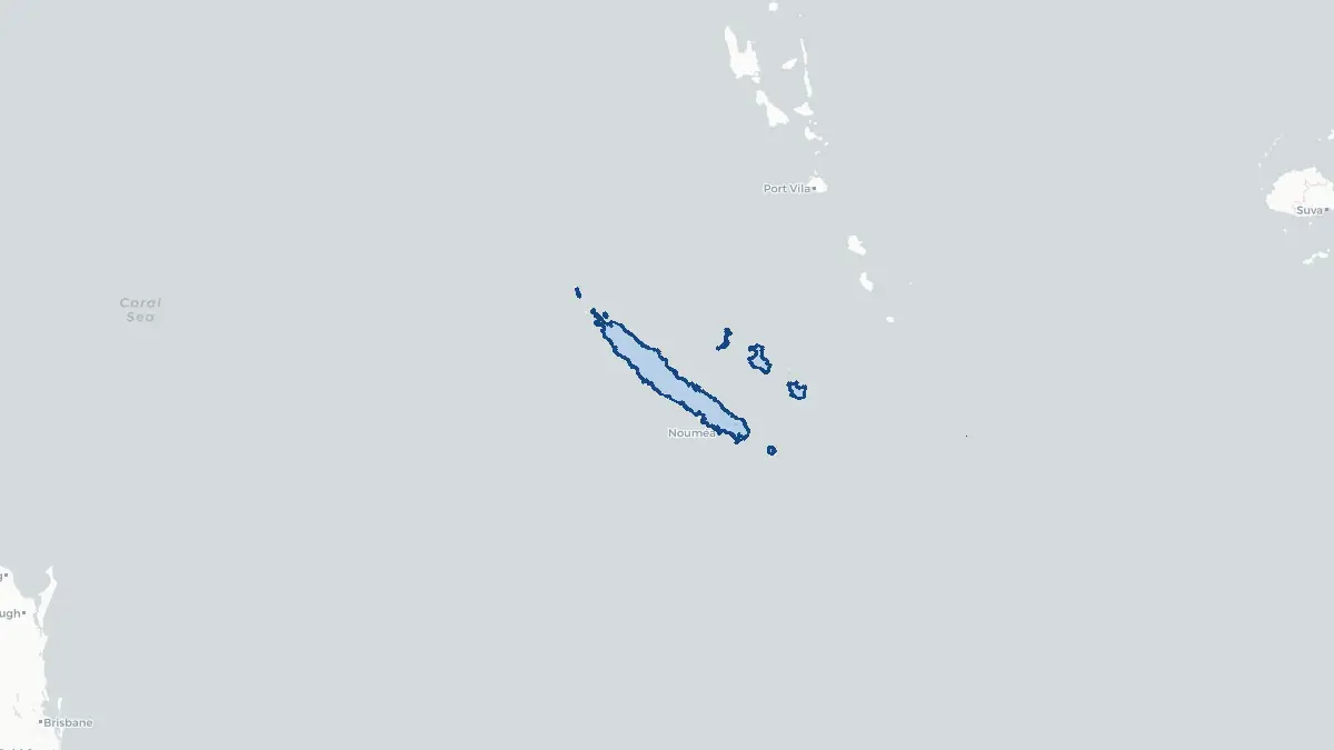
Here you find a map of New Caledonia, capital Noumea, currency CFP-franc and quick links to more facts about the country in Oceania.
About the country
New Caledonia on the map
About New Caledonia
New Caledonia is a special collectivity of France located in the southwestern Pacific Ocean, approximately 1,500 kilometres east of Australia. Its capital and largest city is Nouméa. The total population is around 271,000, composed of the indigenous Kanak people (about 41%), Europeans—primarily of French descent (about 24%)—and various communities of Polynesian, Asian, and mixed heritage. New Caledonia enjoys significant autonomy within the French Republic under the Nouméa Accord of 1998, with its own government, congress, and distinct citizenship. France retains responsibility for defence, foreign affairs, and justice. The economy is dominated by nickel mining and refining; New Caledonia holds some of the world's largest known nickel reserves. Tourism also plays a growing role. A series of referendums on independence—held in 2018, 2020, and 2021—resulted in majorities voting to remain within France, though the political debate continues.
Geography and Landscape
New Caledonia consists of a main island called Grande Terre and several smaller island groups, including the Loyalty Islands (Maré, Lifou, Ouvéa), the Isle of Pines, and the Belep archipelago. Grande Terre is approximately 400 kilometres long and up to 70 kilometres wide, dominated by a central mountain range with peaks reaching over 1,600 metres, notably Mont Panié at 1,628 metres. The western coast of Grande Terre features a broad, dry plain, while the eastern coast is wetter, more rugged, and heavily forested. New Caledonia is surrounded by one of the world's largest lagoons, enclosed by the Grand Récif—a barrier reef stretching over 1,600 kilometres, now a UNESCO World Heritage Site. The climate is tropical, moderated by trade winds, with a warm, humid season from November to April and a cooler, drier period from May to October.
History
New Caledonia has been inhabited by the Kanak people for approximately 3,000 years, with rich traditions of sculpture, oral history, and agriculture centred around yam cultivation. European contact began with British navigator James Cook, who reached the main island in 1774 and named it New Caledonia after the Latin name for Scotland. French missionaries arrived in the 1840s, and France formally annexed the territory in 1853 under Napoleon III, using it first as a penal colony—transporting thousands of convicts and political prisoners, including participants in the Paris Commune of 1871. The territory was opened to free settlers from the 1890s, and nickel mining began to shape its economy. Following World War II, New Caledonia became an overseas territory of France. The late 1980s saw violent conflict between Kanak independence movements and pro-France settlers, resolved through the Matignon Accords (1988) and later the Nouméa Accord (1998), which set out a path toward a self-determination vote.
Geo Quiz
Think you know your capitals, flags, and continents? Take the quiz!
Neighbouring countries
Continue to nearby countries
There are no registered neighbouring countries for New Caledonia in the current database.
More countries in the same part of the world
Oceania index
Open the continent hub for Oceania to see the full country list, capitals and frequently asked questions on one page.
Interactive map
Zoomable map of New Caledonia
Country index
All countries by continent
Jump directly to the right section or keep scrolling.
Africa
58 countries- Algeria
- Angola
- Benin
- Botswana
- Burkina Faso
- Burundi
- Central African Republic
- Djibouti
- Democratic Republic of the Congo
- Egypt
- Equatorial Guinea
- Ivory Coast
- Eritrea
- Ethiopia
- Gabon
- Gambia
- Ghana
- Guinea
- Guinea-Bissau
- Cameroon
- Cape Verde
- Kenya
- Comoros
- Republic of the Congo
- Lesotho
- Liberia
- Libya
- Madagascar
- Malawi
- Mali
- Morocco
- Mauritania
- Mauritius
- Mayotte
- Mozambique
- Namibia
- Niger
- Nigeria
- Reunion
- Rwanda
- Saint Helena
- Sao Tome and Principe
- Senegal
- Seychelles
- Sierra Leone
- Somalia
- Sudan
- Swaziland
- South Africa
- South Sudan
- Tanzania
- Chad
- Togo
- Tunisia
- Uganda
- Western Sahara
- Zambia
- Zimbabwe
Asia
52 countries- Afghanistan
- Armenia
- Azerbaijan
- Bahrain
- Bangladesh
- Bhutan
- British Indian Ocean Territory
- Brunei
- Myanmar
- Philippines
- United Arab Emirates
- Georgia
- Hong Kong
- India
- Indonesia
- Iraq
- Iran
- Israel
- Japan
- Yemen
- Jordan
- Christmas Island
- Cambodia
- Kazakhstan
- China
- Kyrgyzstan
- Cocos Islands
- Kuwait
- Laos
- Lebanon
- Macau
- Malaysia
- Maldives
- Mongolia
- Nepal
- North Korea
- Oman
- Pakistan
- Palestinian Territory
- Qatar
- Saudi Arabia
- Singapore
- Sri Lanka
- South Korea
- Syria
- Tajikistan
- Taiwan
- Thailand
- Turkey
- Turkmenistan
- Uzbekistan
- Vietnam
Europe
53 countries- Albania
- Andorra
- Belgium
- Bosnia and Herzegovina
- Bulgaria
- Cyprus
- Denmark
- Estonia
- Finland
- France
- Faroe Islands
- Gibraltar
- Greece
- Guernsey
- Ireland
- Iceland
- Isle of Man
- Italy
- Jersey
- Kosovo
- Croatia
- Latvia
- Liechtenstein
- Lithuania
- Luxembourg
- Macedonia
- Malta
- Moldova
- Monaco
- Montenegro
- Netherlands
- Norway
- Poland
- Portugal
- Romania
- Russia
- San Marino
- Switzerland
- Serbia
- Slovakia
- Slovenia
- Spain
- United Kingdom
- Svalbard and Jan Mayen
- Sweden
- Czech Republic
- Germany
- Ukraine
- Hungary
- Vatican
- Belarus
- Aland Islands
- Austria
North America
42 countries- U.S. Virgin Islands
- Anguilla
- Antigua and Barbuda
- Aruba
- Bahamas
- Barbados
- Belize
- Bermuda
- Bonaire, Saint Eustatius and Saba
- British Virgin Islands
- Cayman Islands
- Costa Rica
- Curacao
- Dominica
- Dominican Republic
- El Salvador
- Grenada
- Greenland
- Guadeloupe
- Guatemala
- Haiti
- Honduras
- Jamaica
- Canada
- Cuba
- Martinique
- Mexico
- Montserrat
- Netherlands Antilles
- Nicaragua
- Panama
- Puerto Rico
- Saint Barthelemy
- Saint Kitts and Nevis
- Saint Lucia
- Saint Martin
- Saint Vincent and the Grenadines
- Saint Pierre and Miquelon
- Sint Maarten
- Trinidad and Tobago
- Turks and Caicos Islands
- United States
South America
14 countriesOceania
27 countries- American Samoa
- Australia
- Cook Islands
- Fiji
- French Polynesia
- United States Minor Outlying Islands
- Guam
- Kiribati
- Marshall Islands
- Micronesia
- Nauru
- Niue
- Northern Mariana Islands
- Norfolk Island
- New Caledonia
- New Zealand
- Palau
- Papua New Guinea
- Pitcairn
- Solomon Islands
- Samoa
- Tokelau
- Tonga
- Tuvalu
- Vanuatu
- Wallis and Futuna
- East Timor