
Africa
Mauritania — map and facts
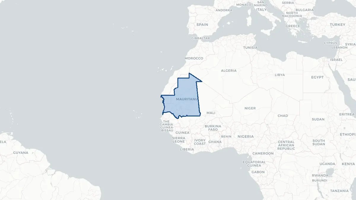
Here you find a map of Mauritania, capital Nouakchott, currency Ouguiya and quick links to more facts about the country in Africa.
About the country
Mauritania on the map
About Mauritania
Mauritania is a large, sparsely populated country in Northwest Africa, bridging the Arab world of the Maghreb and sub-Saharan West Africa. Its population is approximately 4.7 million, and the capital is Nouakchott, a city that has grown from a small settlement at independence to one of the fastest-expanding cities in Africa. Arabic is the official language; Pulaar, Soninke, and Wolof also have national language status. Mauritania is an Islamic republic and has been governed predominantly by the military or former military figures for most of its independent history, with coups occurring in 1978, 1984, 2005, and 2008. President Mohamed Ould Ghazouani, elected in 2019, represents a degree of political continuity. The country holds significant iron ore deposits — among the world's largest — and offshore oil and gas reserves. Despite natural resources, much of the population lives in poverty. Mauritania was the last country in the world to formally abolish slavery, doing so in 1981, though the practice persisted and criminalization of slavery only came in 2007.
Geography and Landscape
Mauritania covers approximately 1.03 million square kilometres. About two-thirds of the country is covered by the Sahara Desert, while the southern tier falls within the Sahel zone. The terrain is predominantly flat, with sandy plains and occasional rocky outcrops called hammada. The Adrar Plateau in the north rises to around 800 metres and shelters ancient oasis towns including Chinguetti and Ouadane, once key stops on trans-Saharan caravan routes. The Richat Structure, also known as the Eye of the Sahara, is a prominent geological feature in the Adrar region, a deeply eroded dome visible from space. The Senegal River forms the country's southern border with Senegal, providing the only consistently fertile agricultural land. The Atlantic coast stretches for about 750 kilometres, and the rich fishing grounds off Cap Blanc and Banc d'Arguin — a UNESCO World Heritage Site and vast wetland of global importance for migratory birds — are ecologically and economically significant.
History
The territory of Mauritania has been inhabited since prehistoric times, with rock art in the Adrar region testifying to ancient human presence. The Ghana Empire, centred further east, had strong influence over trade routes passing through the region. In the 11th century, the Almoravid movement emerged among Sanhaja Berber tribes of the western Sahara and swept northward to conquer Morocco and Spain. Arab Hassaniya-speaking tribes migrated into the region in the 13th and 14th centuries, gradually displacing or absorbing Berber populations. The region came under French influence in the late 19th century, and the colony of Mauritania was formally established in 1904 within French West Africa. Independence was achieved on 28 November 1960 under President Mokhtar Ould Daddah. The 1975 partition of Spanish Sahara drew Mauritania into a costly war with the Polisario Front that lasted until 1979. Political instability through coups characterised subsequent decades, though gold and iron ore production have brought some economic growth.
Geo Quiz
Think you know your capitals, flags, and continents? Take the quiz!
Neighbouring countries
Continue to nearby countries
More countries in the same part of the world
Africa index
Open the continent hub for Africa to see the full country list, capitals and frequently asked questions on one page.
Interactive map
Zoomable map of Mauritania
Country index
All countries by continent
Jump directly to the right section or keep scrolling.
Africa
58 countries- Algeria
- Angola
- Benin
- Botswana
- Burkina Faso
- Burundi
- Central African Republic
- Djibouti
- Democratic Republic of the Congo
- Egypt
- Equatorial Guinea
- Ivory Coast
- Eritrea
- Ethiopia
- Gabon
- Gambia
- Ghana
- Guinea
- Guinea-Bissau
- Cameroon
- Cape Verde
- Kenya
- Comoros
- Republic of the Congo
- Lesotho
- Liberia
- Libya
- Madagascar
- Malawi
- Mali
- Morocco
- Mauritania
- Mauritius
- Mayotte
- Mozambique
- Namibia
- Niger
- Nigeria
- Reunion
- Rwanda
- Saint Helena
- Sao Tome and Principe
- Senegal
- Seychelles
- Sierra Leone
- Somalia
- Sudan
- Swaziland
- South Africa
- South Sudan
- Tanzania
- Chad
- Togo
- Tunisia
- Uganda
- Western Sahara
- Zambia
- Zimbabwe
Asia
52 countries- Afghanistan
- Armenia
- Azerbaijan
- Bahrain
- Bangladesh
- Bhutan
- British Indian Ocean Territory
- Brunei
- Myanmar
- Philippines
- United Arab Emirates
- Georgia
- Hong Kong
- India
- Indonesia
- Iraq
- Iran
- Israel
- Japan
- Yemen
- Jordan
- Christmas Island
- Cambodia
- Kazakhstan
- China
- Kyrgyzstan
- Cocos Islands
- Kuwait
- Laos
- Lebanon
- Macau
- Malaysia
- Maldives
- Mongolia
- Nepal
- North Korea
- Oman
- Pakistan
- Palestinian Territory
- Qatar
- Saudi Arabia
- Singapore
- Sri Lanka
- South Korea
- Syria
- Tajikistan
- Taiwan
- Thailand
- Turkey
- Turkmenistan
- Uzbekistan
- Vietnam
Europe
53 countries- Albania
- Andorra
- Belgium
- Bosnia and Herzegovina
- Bulgaria
- Cyprus
- Denmark
- Estonia
- Finland
- France
- Faroe Islands
- Gibraltar
- Greece
- Guernsey
- Ireland
- Iceland
- Isle of Man
- Italy
- Jersey
- Kosovo
- Croatia
- Latvia
- Liechtenstein
- Lithuania
- Luxembourg
- Macedonia
- Malta
- Moldova
- Monaco
- Montenegro
- Netherlands
- Norway
- Poland
- Portugal
- Romania
- Russia
- San Marino
- Switzerland
- Serbia
- Slovakia
- Slovenia
- Spain
- United Kingdom
- Svalbard and Jan Mayen
- Sweden
- Czech Republic
- Germany
- Ukraine
- Hungary
- Vatican
- Belarus
- Aland Islands
- Austria
North America
42 countries- U.S. Virgin Islands
- Anguilla
- Antigua and Barbuda
- Aruba
- Bahamas
- Barbados
- Belize
- Bermuda
- Bonaire, Saint Eustatius and Saba
- British Virgin Islands
- Cayman Islands
- Costa Rica
- Curacao
- Dominica
- Dominican Republic
- El Salvador
- Grenada
- Greenland
- Guadeloupe
- Guatemala
- Haiti
- Honduras
- Jamaica
- Canada
- Cuba
- Martinique
- Mexico
- Montserrat
- Netherlands Antilles
- Nicaragua
- Panama
- Puerto Rico
- Saint Barthelemy
- Saint Kitts and Nevis
- Saint Lucia
- Saint Martin
- Saint Vincent and the Grenadines
- Saint Pierre and Miquelon
- Sint Maarten
- Trinidad and Tobago
- Turks and Caicos Islands
- United States
South America
14 countriesOceania
27 countries- American Samoa
- Australia
- Cook Islands
- Fiji
- French Polynesia
- United States Minor Outlying Islands
- Guam
- Kiribati
- Marshall Islands
- Micronesia
- Nauru
- Niue
- Northern Mariana Islands
- Norfolk Island
- New Caledonia
- New Zealand
- Palau
- Papua New Guinea
- Pitcairn
- Solomon Islands
- Samoa
- Tokelau
- Tonga
- Tuvalu
- Vanuatu
- Wallis and Futuna
- East Timor