
Africa
Comoros — map and facts
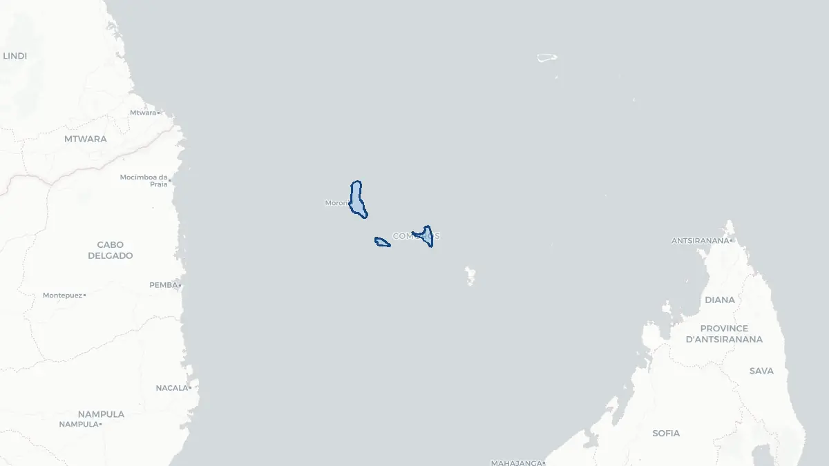
Here you find a map of Comoros, capital Moroni, currency Franc and quick links to more facts about the country in Africa.
About the country
Comoros on the map
About Comoros
Comoros is a small island nation located in the Indian Ocean off the eastern coast of Africa, between the northern tip of Madagascar and the Mozambican coast. Its capital is Moroni, situated on the largest island, Grande Comore. The country has a population of approximately 900,000 people and is one of Africa's smallest and poorest nations. Comoros is a federal presidential republic and a member of the Arab League, reflecting its strong Arab and Islamic cultural heritage. The official languages are Comorian, Arabic, and French. The economy is heavily reliant on remittances from the large diaspora community, agriculture, fishing, and the export of ylang-ylang, vanilla, and cloves, which have historically given the archipelago the nickname "the perfume islands." Comoros has experienced significant political instability, including more than 20 coups or attempted coups since independence, though democratic governance has gradually strengthened in recent years.
Geography and Landscape
Comoros comprises four main volcanic islands — Grande Comore (Ngazidja), Mohéli (Mwali), Anjouan (Ndzuwani), and Mayotte — although Mayotte is administered by France as an overseas department and did not join the independent state. The three islands forming the independent republic lie in the Mozambique Channel. The terrain is dominated by volcanic peaks, lush tropical forest, and fertile coastal lowlands. Mount Karthala on Grande Comore is one of the world's largest and most active shield volcanoes, rising to 2,361 metres and erupting most recently in 2007. The islands are characterised by rugged interiors, dramatic coastlines, and fringing coral reefs that support rich marine biodiversity. The climate is tropical, with a hot, wet season from November to April brought by the monsoon, and a cooler, drier season from May to October. Forests on the upper slopes shelter endemic species of birds and bats found nowhere else on Earth.
History
The Comoros islands were first settled by Bantu-speaking peoples from the African mainland, with later waves of Arab, Persian, and Malay traders and settlers who introduced Islam to the archipelago around the 9th century. Arab sultanates dominated the islands through the medieval period, establishing a distinct Swahili-Arab cultural identity. Portuguese explorers arrived in the early 16th century, followed later by Dutch and French interest. France established a protectorate over the islands in the second half of the 19th century, and in 1912 Comoros became a French colony administered from Madagascar. The islands gained internal autonomy in 1961 and voted for independence in a 1974 referendum, which three of the four islands supported. Comoros unilaterally declared independence on 6 July 1975, while Mayotte voted to remain French. The post-independence era was marked by chronic instability, with secessionist movements on Anjouan and Mohéli in the late 1990s eventually leading to the creation of a new federal structure in 2001.
Geo Quiz
Think you know your capitals, flags, and continents? Take the quiz!
Neighbouring countries
Continue to nearby countries
There are no registered neighbouring countries for Comoros in the current database.
More countries in the same part of the world
Africa index
Open the continent hub for Africa to see the full country list, capitals and frequently asked questions on one page.
Interactive map
Zoomable map of Comoros
Country index
All countries by continent
Jump directly to the right section or keep scrolling.
Africa
58 countries- Algeria
- Angola
- Benin
- Botswana
- Burkina Faso
- Burundi
- Central African Republic
- Djibouti
- Democratic Republic of the Congo
- Egypt
- Equatorial Guinea
- Ivory Coast
- Eritrea
- Ethiopia
- Gabon
- Gambia
- Ghana
- Guinea
- Guinea-Bissau
- Cameroon
- Cape Verde
- Kenya
- Comoros
- Republic of the Congo
- Lesotho
- Liberia
- Libya
- Madagascar
- Malawi
- Mali
- Morocco
- Mauritania
- Mauritius
- Mayotte
- Mozambique
- Namibia
- Niger
- Nigeria
- Reunion
- Rwanda
- Saint Helena
- Sao Tome and Principe
- Senegal
- Seychelles
- Sierra Leone
- Somalia
- Sudan
- Swaziland
- South Africa
- South Sudan
- Tanzania
- Chad
- Togo
- Tunisia
- Uganda
- Western Sahara
- Zambia
- Zimbabwe
Asia
52 countries- Afghanistan
- Armenia
- Azerbaijan
- Bahrain
- Bangladesh
- Bhutan
- British Indian Ocean Territory
- Brunei
- Myanmar
- Philippines
- United Arab Emirates
- Georgia
- Hong Kong
- India
- Indonesia
- Iraq
- Iran
- Israel
- Japan
- Yemen
- Jordan
- Christmas Island
- Cambodia
- Kazakhstan
- China
- Kyrgyzstan
- Cocos Islands
- Kuwait
- Laos
- Lebanon
- Macau
- Malaysia
- Maldives
- Mongolia
- Nepal
- North Korea
- Oman
- Pakistan
- Palestinian Territory
- Qatar
- Saudi Arabia
- Singapore
- Sri Lanka
- South Korea
- Syria
- Tajikistan
- Taiwan
- Thailand
- Turkey
- Turkmenistan
- Uzbekistan
- Vietnam
Europe
53 countries- Albania
- Andorra
- Belgium
- Bosnia and Herzegovina
- Bulgaria
- Cyprus
- Denmark
- Estonia
- Finland
- France
- Faroe Islands
- Gibraltar
- Greece
- Guernsey
- Ireland
- Iceland
- Isle of Man
- Italy
- Jersey
- Kosovo
- Croatia
- Latvia
- Liechtenstein
- Lithuania
- Luxembourg
- Macedonia
- Malta
- Moldova
- Monaco
- Montenegro
- Netherlands
- Norway
- Poland
- Portugal
- Romania
- Russia
- San Marino
- Switzerland
- Serbia
- Slovakia
- Slovenia
- Spain
- United Kingdom
- Svalbard and Jan Mayen
- Sweden
- Czech Republic
- Germany
- Ukraine
- Hungary
- Vatican
- Belarus
- Aland Islands
- Austria
North America
42 countries- U.S. Virgin Islands
- Anguilla
- Antigua and Barbuda
- Aruba
- Bahamas
- Barbados
- Belize
- Bermuda
- Bonaire, Saint Eustatius and Saba
- British Virgin Islands
- Cayman Islands
- Costa Rica
- Curacao
- Dominica
- Dominican Republic
- El Salvador
- Grenada
- Greenland
- Guadeloupe
- Guatemala
- Haiti
- Honduras
- Jamaica
- Canada
- Cuba
- Martinique
- Mexico
- Montserrat
- Netherlands Antilles
- Nicaragua
- Panama
- Puerto Rico
- Saint Barthelemy
- Saint Kitts and Nevis
- Saint Lucia
- Saint Martin
- Saint Vincent and the Grenadines
- Saint Pierre and Miquelon
- Sint Maarten
- Trinidad and Tobago
- Turks and Caicos Islands
- United States
South America
14 countriesOceania
27 countries- American Samoa
- Australia
- Cook Islands
- Fiji
- French Polynesia
- United States Minor Outlying Islands
- Guam
- Kiribati
- Marshall Islands
- Micronesia
- Nauru
- Niue
- Northern Mariana Islands
- Norfolk Island
- New Caledonia
- New Zealand
- Palau
- Papua New Guinea
- Pitcairn
- Solomon Islands
- Samoa
- Tokelau
- Tonga
- Tuvalu
- Vanuatu
- Wallis and Futuna
- East Timor