
Africa
Cameroon — map and facts
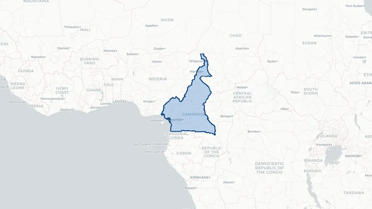
Here you find a map of Cameroon, capital Yaounde, currency Franc and quick links to more facts about the country in Africa.
About the country
Cameroon on the map
#### About Cameroon Cameroon is a Central African nation often described as "Africa in miniature" due to its extraordinary cultural and environmental diversity. It borders Nigeria to the northwest, Chad to the northeast, the Central African Republic to the east, and the Republic of the Congo, Gabon, and Equatorial Guinea to the south. With a population exceeding 27 million people, the country is home to more than 250 ethnic groups speaking hundreds of distinct languages. Yaoundé serves as the political capital while Douala, the economic hub, functions as the main port city. Cameroon is a bilingual state, with both French and English serving as official languages, a legacy of its dual colonial history under France and Britain.
#### Geography and Landscape Cameroon's terrain transitions through five distinct geographic zones. The coastal lowlands in the south give way to a densely forested plateau, which rises toward the Adamawa Highlands in the centre of the country. The north opens into progressively drier savanna before reaching the semi-arid Lake Chad basin. Mount Cameroon, an active stratovolcano rising to 4,095 metres, is the highest peak in West and Central Africa and one of the continent's most active volcanoes. The country's extensive river systems include the Sanaga and Benue, and the southern rainforests form part of the Congo Basin ecosystem, one of the world's largest tropical forest reserves.
#### History The territory that is now Cameroon was first contacted by Portuguese explorers in the fifteenth century, who named the Wouri River estuary "Rio dos Camarões" after the abundance of shrimp found there. Germany colonised the region as Kamerun in 1884, developing infrastructure and establishing plantations. Following World War One, the territory was partitioned between France and Britain under League of Nations mandates. French Cameroun gained independence in 1960, and the following year a UN plebiscite resulted in the southern part of British Cameroons joining to form the Federal Republic of Cameroon. The country became a unitary state in 1972. Since 2016, an anglophone separatist crisis has created significant instability in the northwest and southwest regions.
Geo Quiz
Think you know your capitals, flags, and continents? Take the quiz!
Neighbouring countries
Continue to nearby countries
More countries in the same part of the world
Africa index
Open the continent hub for Africa to see the full country list, capitals and frequently asked questions on one page.
Interactive map
Zoomable map of Cameroon
Country index
All countries by continent
Jump directly to the right section or keep scrolling.
Africa
58 countries- Algeria
- Angola
- Benin
- Botswana
- Burkina Faso
- Burundi
- Central African Republic
- Djibouti
- Democratic Republic of the Congo
- Egypt
- Equatorial Guinea
- Ivory Coast
- Eritrea
- Ethiopia
- Gabon
- Gambia
- Ghana
- Guinea
- Guinea-Bissau
- Cameroon
- Cape Verde
- Kenya
- Comoros
- Republic of the Congo
- Lesotho
- Liberia
- Libya
- Madagascar
- Malawi
- Mali
- Morocco
- Mauritania
- Mauritius
- Mayotte
- Mozambique
- Namibia
- Niger
- Nigeria
- Reunion
- Rwanda
- Saint Helena
- Sao Tome and Principe
- Senegal
- Seychelles
- Sierra Leone
- Somalia
- Sudan
- Swaziland
- South Africa
- South Sudan
- Tanzania
- Chad
- Togo
- Tunisia
- Uganda
- Western Sahara
- Zambia
- Zimbabwe
Asia
52 countries- Afghanistan
- Armenia
- Azerbaijan
- Bahrain
- Bangladesh
- Bhutan
- British Indian Ocean Territory
- Brunei
- Myanmar
- Philippines
- United Arab Emirates
- Georgia
- Hong Kong
- India
- Indonesia
- Iraq
- Iran
- Israel
- Japan
- Yemen
- Jordan
- Christmas Island
- Cambodia
- Kazakhstan
- China
- Kyrgyzstan
- Cocos Islands
- Kuwait
- Laos
- Lebanon
- Macau
- Malaysia
- Maldives
- Mongolia
- Nepal
- North Korea
- Oman
- Pakistan
- Palestinian Territory
- Qatar
- Saudi Arabia
- Singapore
- Sri Lanka
- South Korea
- Syria
- Tajikistan
- Taiwan
- Thailand
- Turkey
- Turkmenistan
- Uzbekistan
- Vietnam
Europe
53 countries- Albania
- Andorra
- Belgium
- Bosnia and Herzegovina
- Bulgaria
- Cyprus
- Denmark
- Estonia
- Finland
- France
- Faroe Islands
- Gibraltar
- Greece
- Guernsey
- Ireland
- Iceland
- Isle of Man
- Italy
- Jersey
- Kosovo
- Croatia
- Latvia
- Liechtenstein
- Lithuania
- Luxembourg
- Macedonia
- Malta
- Moldova
- Monaco
- Montenegro
- Netherlands
- Norway
- Poland
- Portugal
- Romania
- Russia
- San Marino
- Switzerland
- Serbia
- Slovakia
- Slovenia
- Spain
- United Kingdom
- Svalbard and Jan Mayen
- Sweden
- Czech Republic
- Germany
- Ukraine
- Hungary
- Vatican
- Belarus
- Aland Islands
- Austria
North America
42 countries- U.S. Virgin Islands
- Anguilla
- Antigua and Barbuda
- Aruba
- Bahamas
- Barbados
- Belize
- Bermuda
- Bonaire, Saint Eustatius and Saba
- British Virgin Islands
- Cayman Islands
- Costa Rica
- Curacao
- Dominica
- Dominican Republic
- El Salvador
- Grenada
- Greenland
- Guadeloupe
- Guatemala
- Haiti
- Honduras
- Jamaica
- Canada
- Cuba
- Martinique
- Mexico
- Montserrat
- Netherlands Antilles
- Nicaragua
- Panama
- Puerto Rico
- Saint Barthelemy
- Saint Kitts and Nevis
- Saint Lucia
- Saint Martin
- Saint Vincent and the Grenadines
- Saint Pierre and Miquelon
- Sint Maarten
- Trinidad and Tobago
- Turks and Caicos Islands
- United States
South America
14 countriesOceania
27 countries- American Samoa
- Australia
- Cook Islands
- Fiji
- French Polynesia
- United States Minor Outlying Islands
- Guam
- Kiribati
- Marshall Islands
- Micronesia
- Nauru
- Niue
- Northern Mariana Islands
- Norfolk Island
- New Caledonia
- New Zealand
- Palau
- Papua New Guinea
- Pitcairn
- Solomon Islands
- Samoa
- Tokelau
- Tonga
- Tuvalu
- Vanuatu
- Wallis and Futuna
- East Timor