
Europe
Slovakia — map and facts
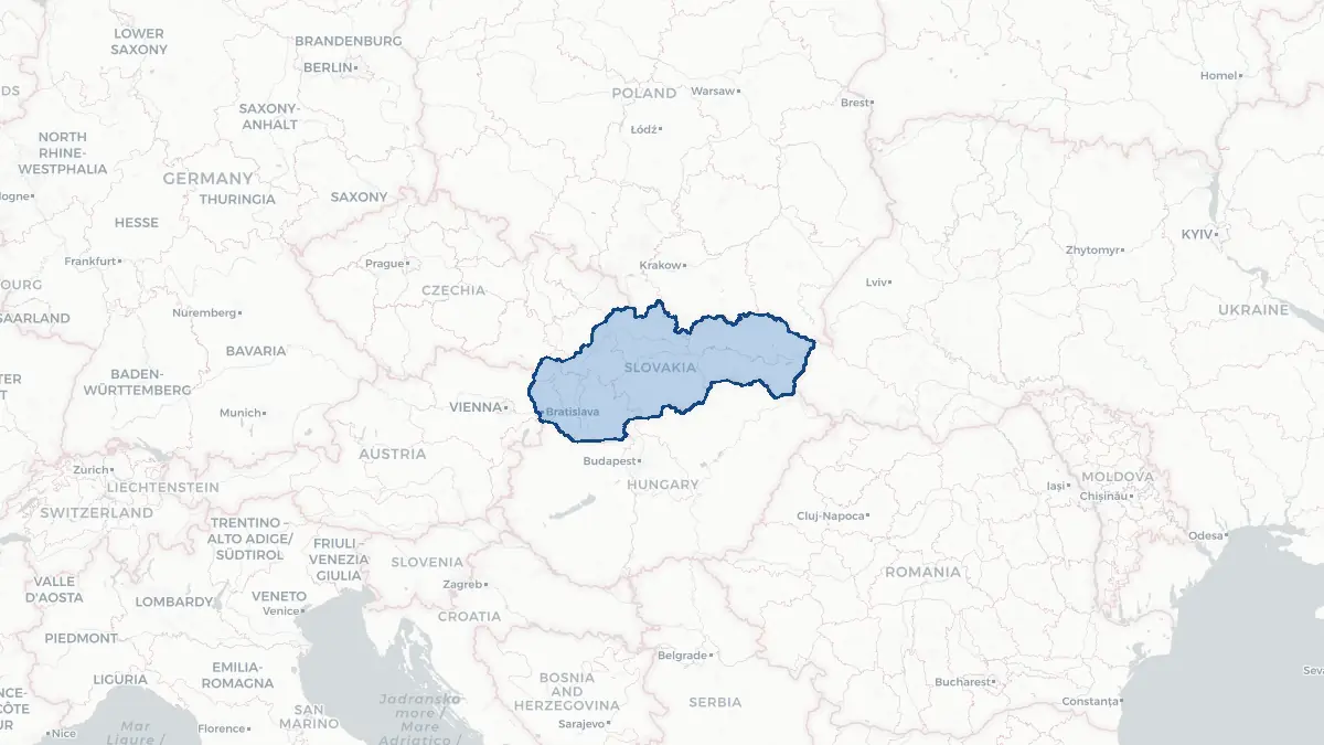
Here you find a map of Slovakia, capital Bratislava, currency Euro and quick links to more facts about the country in Europe.
About the country
Slovakia on the map
About Slovakia
Slovakia is a landlocked Central European country of approximately 5.5 million people, bordered by the Czech Republic, Austria, Hungary, Ukraine, and Poland. Its capital is Bratislava, located on the Danube and unique in being a capital city that borders two other countries (Austria and Hungary). Slovakia became independent on 1 January 1993 following the peaceful dissolution of Czechoslovakia, known as the Velvet Divorce. It joined NATO and the EU in 2004 and adopted the euro in 2009. The official language is Slovak, a West Slavic language closely related to Czech. Slovakia has a diversified economy, strong in automotive manufacturing, electronics, and services; it is one of the world's largest producers of cars per capita.
Geography and Landscape
Slovakia's landscape is dominated by mountains in the centre and north, with the High Tatras (Vysoké Tatry) forming a dramatic alpine skyline along the Polish border, reaching 2,655 metres at Gerlachovský štít — the highest point in the Carpathian range. The Western and Low Tatras, the Slovak Ore Mountains, and the Fatra and Beskydy ranges cover much of the country. The southern lowlands along the Danube and its tributaries are the main agricultural zone, merging with Hungary's Great Plain. Major rivers include the Danube (forming the southern border), the Váh, the Nitra, and the Hron. Slovakia has over 1,300 caves, several with UNESCO status, and hot spring resorts. The climate is temperate continental, with cold winters and warm summers.
History
The territory of modern Slovakia was part of the Great Moravian Empire in the ninth century, which Christianised under Saints Cyril and Methodius. After the fall of Moravia, the region was conquered by the Hungarians around 900 AD and remained part of the Kingdom of Hungary for almost a thousand years. The capital of Hungary was Bratislava (then called Pozsony) from 1563 to 1783. Slovak national consciousness emerged in the nineteenth century through scholars such as ?udovít Štúr, who codified the Slovak literary language. After the First World War, Slovakia united with the Czech lands to form Czechoslovakia in 1918. A puppet Slovak state existed under Nazi Germany's patronage during the Second World War. After 1948, Czechoslovakia became communist. The Velvet Revolution of 1989 ended communist rule; the country peacefully split into Slovakia and the Czech Republic on 1 January 1993.
Geo Quiz
Think you know your capitals, flags, and continents? Take the quiz!
Neighbouring countries
Continue to nearby countries
More countries in the same part of the world
Europe index
Open the continent hub for Europe to see the full country list, capitals and frequently asked questions on one page.
Interactive map
Zoomable map of Slovakia
Country index
All countries by continent
Jump directly to the right section or keep scrolling.
Africa
58 countries- Algeria
- Angola
- Benin
- Botswana
- Burkina Faso
- Burundi
- Central African Republic
- Djibouti
- Democratic Republic of the Congo
- Egypt
- Equatorial Guinea
- Ivory Coast
- Eritrea
- Ethiopia
- Gabon
- Gambia
- Ghana
- Guinea
- Guinea-Bissau
- Cameroon
- Cape Verde
- Kenya
- Comoros
- Republic of the Congo
- Lesotho
- Liberia
- Libya
- Madagascar
- Malawi
- Mali
- Morocco
- Mauritania
- Mauritius
- Mayotte
- Mozambique
- Namibia
- Niger
- Nigeria
- Reunion
- Rwanda
- Saint Helena
- Sao Tome and Principe
- Senegal
- Seychelles
- Sierra Leone
- Somalia
- Sudan
- Swaziland
- South Africa
- South Sudan
- Tanzania
- Chad
- Togo
- Tunisia
- Uganda
- Western Sahara
- Zambia
- Zimbabwe
Asia
52 countries- Afghanistan
- Armenia
- Azerbaijan
- Bahrain
- Bangladesh
- Bhutan
- British Indian Ocean Territory
- Brunei
- Myanmar
- Philippines
- United Arab Emirates
- Georgia
- Hong Kong
- India
- Indonesia
- Iraq
- Iran
- Israel
- Japan
- Yemen
- Jordan
- Christmas Island
- Cambodia
- Kazakhstan
- China
- Kyrgyzstan
- Cocos Islands
- Kuwait
- Laos
- Lebanon
- Macau
- Malaysia
- Maldives
- Mongolia
- Nepal
- North Korea
- Oman
- Pakistan
- Palestinian Territory
- Qatar
- Saudi Arabia
- Singapore
- Sri Lanka
- South Korea
- Syria
- Tajikistan
- Taiwan
- Thailand
- Turkey
- Turkmenistan
- Uzbekistan
- Vietnam
Europe
53 countries- Albania
- Andorra
- Belgium
- Bosnia and Herzegovina
- Bulgaria
- Cyprus
- Denmark
- Estonia
- Finland
- France
- Faroe Islands
- Gibraltar
- Greece
- Guernsey
- Ireland
- Iceland
- Isle of Man
- Italy
- Jersey
- Kosovo
- Croatia
- Latvia
- Liechtenstein
- Lithuania
- Luxembourg
- Macedonia
- Malta
- Moldova
- Monaco
- Montenegro
- Netherlands
- Norway
- Poland
- Portugal
- Romania
- Russia
- San Marino
- Switzerland
- Serbia
- Slovakia
- Slovenia
- Spain
- United Kingdom
- Svalbard and Jan Mayen
- Sweden
- Czech Republic
- Germany
- Ukraine
- Hungary
- Vatican
- Belarus
- Aland Islands
- Austria
North America
42 countries- U.S. Virgin Islands
- Anguilla
- Antigua and Barbuda
- Aruba
- Bahamas
- Barbados
- Belize
- Bermuda
- Bonaire, Saint Eustatius and Saba
- British Virgin Islands
- Cayman Islands
- Costa Rica
- Curacao
- Dominica
- Dominican Republic
- El Salvador
- Grenada
- Greenland
- Guadeloupe
- Guatemala
- Haiti
- Honduras
- Jamaica
- Canada
- Cuba
- Martinique
- Mexico
- Montserrat
- Netherlands Antilles
- Nicaragua
- Panama
- Puerto Rico
- Saint Barthelemy
- Saint Kitts and Nevis
- Saint Lucia
- Saint Martin
- Saint Vincent and the Grenadines
- Saint Pierre and Miquelon
- Sint Maarten
- Trinidad and Tobago
- Turks and Caicos Islands
- United States
South America
14 countriesOceania
27 countries- American Samoa
- Australia
- Cook Islands
- Fiji
- French Polynesia
- United States Minor Outlying Islands
- Guam
- Kiribati
- Marshall Islands
- Micronesia
- Nauru
- Niue
- Northern Mariana Islands
- Norfolk Island
- New Caledonia
- New Zealand
- Palau
- Papua New Guinea
- Pitcairn
- Solomon Islands
- Samoa
- Tokelau
- Tonga
- Tuvalu
- Vanuatu
- Wallis and Futuna
- East Timor