
Europe
Estonia — map and facts
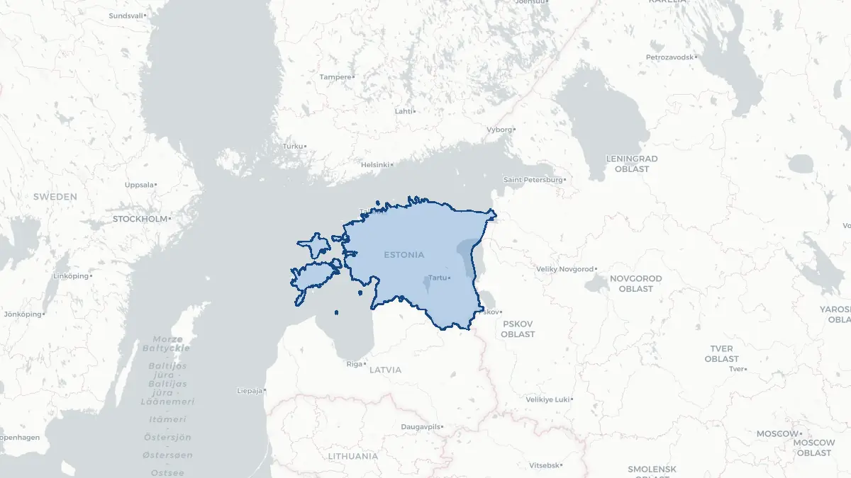
Here you find a map of Estonia, capital Tallinn, currency Euro and quick links to more facts about the country in Europe.
About the country
Estonia on the map
About Estonia
Estonia is a small Baltic state of approximately 1.3 million people in northern Europe, bordering Latvia to the south and Russia to the east, with a coastline on the Baltic Sea and the Gulf of Finland. Its capital is Tallinn, a beautifully preserved medieval city and the country's economic and cultural centre. Estonia regained independence from the Soviet Union in 1991 and has since undergone a remarkable transformation, becoming one of the most digitally advanced societies in the world — it pioneered e-residency, digital voting, and online government services. Estonia is a NATO member since 2004 and an EU member since 2004. The official language is Estonian, a Finno-Ugric language closely related to Finnish. The population is relatively small but ethnically mixed, with ethnic Estonians comprising about two-thirds and a significant Russian-speaking minority.
Geography and Landscape
Estonia is characterised by low-lying, flat or gently rolling terrain, extensive forests covering over half the country, and thousands of lakes, rivers, and wetlands. The highest point is Suur Munamägi at just 318 metres. Estonia has over 2,200 islands and islets, including the larger islands of Saaremaa and Hiiumaa in the west. The coastline is deeply indented, with numerous bays, peninsulas, and archipelagos. Major rivers include the Emajõgi, which flows through the university city of Tartu. Lake Võrtsjärv is the largest entirely within Estonia. The Baltic coast and island areas have a milder maritime climate, while the interior is more continental with cold winters. The boreal forest and peat bog ecosystems are distinctive and host wolf, lynx, and brown bear populations.
History
Estonians are among the oldest indigenous peoples of Europe, with a distinct language and culture predating written history. Danish and German crusaders arrived in the thirteenth century; the Teutonic Knights and the Livonian Order dominated the region for centuries. Sweden controlled Estonia from the early seventeenth century until the Great Northern War, when Russia took possession in 1710. Estonian national consciousness grew throughout the nineteenth century, culminating in the first Song Festival in 1869 — a tradition that continues today. Estonia declared independence in 1918 and maintained it through 1940, when the Soviet Union occupied and annexed the country. German occupation followed (1941–1944) before Soviet rule resumed until 1991. The Singing Revolution (1987–1991), marked by mass peaceful protests and a human chain linking all three Baltic states, led to the restoration of independence on 20 August 1991.
Geo Quiz
Think you know your capitals, flags, and continents? Take the quiz!
Neighbouring countries
Continue to nearby countries
More countries in the same part of the world
Europe index
Open the continent hub for Europe to see the full country list, capitals and frequently asked questions on one page.
Interactive map
Zoomable map of Estonia
Country index
All countries by continent
Jump directly to the right section or keep scrolling.
Africa
58 countries- Algeria
- Angola
- Benin
- Botswana
- Burkina Faso
- Burundi
- Central African Republic
- Djibouti
- Democratic Republic of the Congo
- Egypt
- Equatorial Guinea
- Ivory Coast
- Eritrea
- Ethiopia
- Gabon
- Gambia
- Ghana
- Guinea
- Guinea-Bissau
- Cameroon
- Cape Verde
- Kenya
- Comoros
- Republic of the Congo
- Lesotho
- Liberia
- Libya
- Madagascar
- Malawi
- Mali
- Morocco
- Mauritania
- Mauritius
- Mayotte
- Mozambique
- Namibia
- Niger
- Nigeria
- Reunion
- Rwanda
- Saint Helena
- Sao Tome and Principe
- Senegal
- Seychelles
- Sierra Leone
- Somalia
- Sudan
- Swaziland
- South Africa
- South Sudan
- Tanzania
- Chad
- Togo
- Tunisia
- Uganda
- Western Sahara
- Zambia
- Zimbabwe
Asia
52 countries- Afghanistan
- Armenia
- Azerbaijan
- Bahrain
- Bangladesh
- Bhutan
- British Indian Ocean Territory
- Brunei
- Myanmar
- Philippines
- United Arab Emirates
- Georgia
- Hong Kong
- India
- Indonesia
- Iraq
- Iran
- Israel
- Japan
- Yemen
- Jordan
- Christmas Island
- Cambodia
- Kazakhstan
- China
- Kyrgyzstan
- Cocos Islands
- Kuwait
- Laos
- Lebanon
- Macau
- Malaysia
- Maldives
- Mongolia
- Nepal
- North Korea
- Oman
- Pakistan
- Palestinian Territory
- Qatar
- Saudi Arabia
- Singapore
- Sri Lanka
- South Korea
- Syria
- Tajikistan
- Taiwan
- Thailand
- Turkey
- Turkmenistan
- Uzbekistan
- Vietnam
Europe
53 countries- Albania
- Andorra
- Belgium
- Bosnia and Herzegovina
- Bulgaria
- Cyprus
- Denmark
- Estonia
- Finland
- France
- Faroe Islands
- Gibraltar
- Greece
- Guernsey
- Ireland
- Iceland
- Isle of Man
- Italy
- Jersey
- Kosovo
- Croatia
- Latvia
- Liechtenstein
- Lithuania
- Luxembourg
- Macedonia
- Malta
- Moldova
- Monaco
- Montenegro
- Netherlands
- Norway
- Poland
- Portugal
- Romania
- Russia
- San Marino
- Switzerland
- Serbia
- Slovakia
- Slovenia
- Spain
- United Kingdom
- Svalbard and Jan Mayen
- Sweden
- Czech Republic
- Germany
- Ukraine
- Hungary
- Vatican
- Belarus
- Aland Islands
- Austria
North America
42 countries- U.S. Virgin Islands
- Anguilla
- Antigua and Barbuda
- Aruba
- Bahamas
- Barbados
- Belize
- Bermuda
- Bonaire, Saint Eustatius and Saba
- British Virgin Islands
- Cayman Islands
- Costa Rica
- Curacao
- Dominica
- Dominican Republic
- El Salvador
- Grenada
- Greenland
- Guadeloupe
- Guatemala
- Haiti
- Honduras
- Jamaica
- Canada
- Cuba
- Martinique
- Mexico
- Montserrat
- Netherlands Antilles
- Nicaragua
- Panama
- Puerto Rico
- Saint Barthelemy
- Saint Kitts and Nevis
- Saint Lucia
- Saint Martin
- Saint Vincent and the Grenadines
- Saint Pierre and Miquelon
- Sint Maarten
- Trinidad and Tobago
- Turks and Caicos Islands
- United States
South America
14 countriesOceania
27 countries- American Samoa
- Australia
- Cook Islands
- Fiji
- French Polynesia
- United States Minor Outlying Islands
- Guam
- Kiribati
- Marshall Islands
- Micronesia
- Nauru
- Niue
- Northern Mariana Islands
- Norfolk Island
- New Caledonia
- New Zealand
- Palau
- Papua New Guinea
- Pitcairn
- Solomon Islands
- Samoa
- Tokelau
- Tonga
- Tuvalu
- Vanuatu
- Wallis and Futuna
- East Timor