
Oceania
Solomon Islands — map and facts
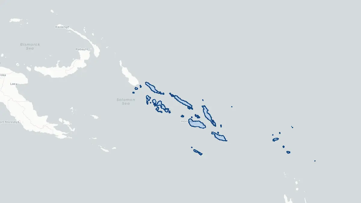
Here you find a map of Solomon Islands, capital Honiara, currency Salomondollar and quick links to more facts about the country in Oceania.
About the country
Solomon Islands on the map
About Solomon Islands
Solomon Islands is an archipelago nation in the southwestern Pacific Ocean, located northeast of Australia and southeast of Papua New Guinea. The capital is Honiara, situated on the island of Guadalcanal, and the population is approximately 750,000 people. Solomon Islands gained independence from Britain on 7 July 1978 and is a constitutional monarchy with the British monarch as head of state. The country consists of nearly 1,000 islands spread across a chain stretching approximately 1,500 kilometres, though six main islands account for most of the land area: Guadalcanal, Malaita, New Georgia, San Cristobal, Santa Isabel, and Choiseul. The economy depends primarily on subsistence agriculture, fishing, and forestry. Solomon Islands is home to remarkable biodiversity, both on land and in its surrounding seas, and is part of the Coral Triangle. The country has experienced periods of civil unrest, most notably the ethnic tensions between 1998 and 2003 known locally as "the Tensions."
Geography and Landscape
Solomon Islands forms a double chain of islands running northwest to southeast across the southwestern Pacific. The larger islands are mountainous, heavily forested, and of volcanic origin, with rugged interiors and narrow coastal plains. Guadalcanal is the largest island and reaches a maximum elevation of 2,447 metres at Mount Popomanaseu. The islands are surrounded by extensive coral reef systems, lagoons, and shallow coastal waters of exceptional marine richness. The climate is tropical, hot and humid throughout the year, with heavy rainfall particularly in the interior highlands. The islands receive between 3,000 and 8,000 millimetres of rain annually, making them among the wettest in the Pacific. The New Georgia Sound, also known as The Slot, is a major channel running between the island chains. Active volcanoes are present on some islands, including Savo and Tinakula, and the country experiences frequent seismic activity.
History
The Solomon Islands have been inhabited for at least 30,000 years, with subsequent waves of Melanesian, Polynesian, and Micronesian settlement. Spanish explorer Álvaro de Mendaña de Neira was the first European to reach the islands in 1568, naming them after the biblical King Solomon in hopes of finding gold. European contact was limited until the nineteenth century, when missionaries and traders arrived in increasing numbers. Britain established a protectorate over the southern islands in 1893, later extended to cover the entire group. The islands became a major theatre of World War Two following the Japanese occupation of 1942, with the Battle of Guadalcanal representing one of the most significant and bloody campaigns of the Pacific War. After the war, the islands remained under British administration until independence in 1978. Between 1998 and 2003, ethnic tensions between the people of Guadalcanal and Malaita led to significant civil conflict, resolved in part through the Regional Assistance Mission to Solomon Islands.
Geo Quiz
Think you know your capitals, flags, and continents? Take the quiz!
Neighbouring countries
Continue to nearby countries
There are no registered neighbouring countries for Solomon Islands in the current database.
More countries in the same part of the world
Oceania index
Open the continent hub for Oceania to see the full country list, capitals and frequently asked questions on one page.
Interactive map
Zoomable map of Solomon Islands
Country index
All countries by continent
Jump directly to the right section or keep scrolling.
Africa
58 countries- Algeria
- Angola
- Benin
- Botswana
- Burkina Faso
- Burundi
- Central African Republic
- Djibouti
- Democratic Republic of the Congo
- Egypt
- Equatorial Guinea
- Ivory Coast
- Eritrea
- Ethiopia
- Gabon
- Gambia
- Ghana
- Guinea
- Guinea-Bissau
- Cameroon
- Cape Verde
- Kenya
- Comoros
- Republic of the Congo
- Lesotho
- Liberia
- Libya
- Madagascar
- Malawi
- Mali
- Morocco
- Mauritania
- Mauritius
- Mayotte
- Mozambique
- Namibia
- Niger
- Nigeria
- Reunion
- Rwanda
- Saint Helena
- Sao Tome and Principe
- Senegal
- Seychelles
- Sierra Leone
- Somalia
- Sudan
- Swaziland
- South Africa
- South Sudan
- Tanzania
- Chad
- Togo
- Tunisia
- Uganda
- Western Sahara
- Zambia
- Zimbabwe
Asia
52 countries- Afghanistan
- Armenia
- Azerbaijan
- Bahrain
- Bangladesh
- Bhutan
- British Indian Ocean Territory
- Brunei
- Myanmar
- Philippines
- United Arab Emirates
- Georgia
- Hong Kong
- India
- Indonesia
- Iraq
- Iran
- Israel
- Japan
- Yemen
- Jordan
- Christmas Island
- Cambodia
- Kazakhstan
- China
- Kyrgyzstan
- Cocos Islands
- Kuwait
- Laos
- Lebanon
- Macau
- Malaysia
- Maldives
- Mongolia
- Nepal
- North Korea
- Oman
- Pakistan
- Palestinian Territory
- Qatar
- Saudi Arabia
- Singapore
- Sri Lanka
- South Korea
- Syria
- Tajikistan
- Taiwan
- Thailand
- Turkey
- Turkmenistan
- Uzbekistan
- Vietnam
Europe
53 countries- Albania
- Andorra
- Belgium
- Bosnia and Herzegovina
- Bulgaria
- Cyprus
- Denmark
- Estonia
- Finland
- France
- Faroe Islands
- Gibraltar
- Greece
- Guernsey
- Ireland
- Iceland
- Isle of Man
- Italy
- Jersey
- Kosovo
- Croatia
- Latvia
- Liechtenstein
- Lithuania
- Luxembourg
- Macedonia
- Malta
- Moldova
- Monaco
- Montenegro
- Netherlands
- Norway
- Poland
- Portugal
- Romania
- Russia
- San Marino
- Switzerland
- Serbia
- Slovakia
- Slovenia
- Spain
- United Kingdom
- Svalbard and Jan Mayen
- Sweden
- Czech Republic
- Germany
- Ukraine
- Hungary
- Vatican
- Belarus
- Aland Islands
- Austria
North America
42 countries- U.S. Virgin Islands
- Anguilla
- Antigua and Barbuda
- Aruba
- Bahamas
- Barbados
- Belize
- Bermuda
- Bonaire, Saint Eustatius and Saba
- British Virgin Islands
- Cayman Islands
- Costa Rica
- Curacao
- Dominica
- Dominican Republic
- El Salvador
- Grenada
- Greenland
- Guadeloupe
- Guatemala
- Haiti
- Honduras
- Jamaica
- Canada
- Cuba
- Martinique
- Mexico
- Montserrat
- Netherlands Antilles
- Nicaragua
- Panama
- Puerto Rico
- Saint Barthelemy
- Saint Kitts and Nevis
- Saint Lucia
- Saint Martin
- Saint Vincent and the Grenadines
- Saint Pierre and Miquelon
- Sint Maarten
- Trinidad and Tobago
- Turks and Caicos Islands
- United States
South America
14 countriesOceania
27 countries- American Samoa
- Australia
- Cook Islands
- Fiji
- French Polynesia
- United States Minor Outlying Islands
- Guam
- Kiribati
- Marshall Islands
- Micronesia
- Nauru
- Niue
- Northern Mariana Islands
- Norfolk Island
- New Caledonia
- New Zealand
- Palau
- Papua New Guinea
- Pitcairn
- Solomon Islands
- Samoa
- Tokelau
- Tonga
- Tuvalu
- Vanuatu
- Wallis and Futuna
- East Timor