
Asia
Armenia — map and facts
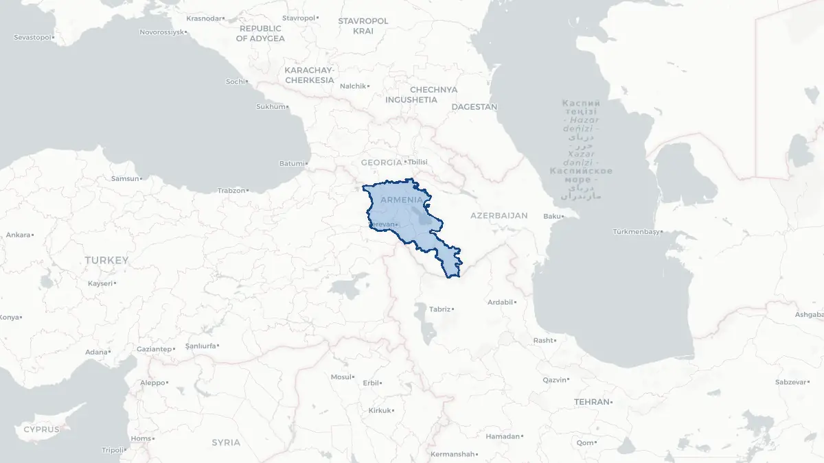
Here you find a map of Armenia, capital Yerevan, currency Dram and quick links to more facts about the country in Asia.
About the country
Armenia on the map
About Armenia
Armenia is a landlocked republic in the South Caucasus region with a population of approximately 3 million people. Yerevan, situated in the Ararat Plain, is the capital and by far the largest city. Armenia is one of the world's oldest continuously inhabited regions and holds the distinction of being the first nation to adopt Christianity as a state religion, in 301 CE. The country operates as a semi-presidential republic and is a member of the Eurasian Economic Union. The Armenian economy relies on mining, agriculture, information technology, and significant remittances from the large Armenian diaspora, estimated at over 7 million people worldwide. The country maintains a complex geopolitical position, with borders closed to Turkey and Azerbaijan due to longstanding disputes, most critically over the Nagorno-Karabakh region. Following a 2023 Azerbaijani military operation, Armenian forces and population withdrew from Nagorno-Karabakh entirely. Armenia borders Georgia to the north, Azerbaijan to the east, Iran to the south, and Turkey to the west.
Geography and Landscape
Armenia occupies approximately 29,743 square kilometres of predominantly mountainous terrain in the South Caucasus. Mount Aragats, at 4,090 metres, is the highest peak within the country, while the culturally iconic Mount Ararat — visible from Yerevan — stands across the border in Turkey. The Armenian Highlands form the backbone of the landscape, with an average elevation exceeding 1,800 metres above sea level. Lake Sevan, one of the largest freshwater alpine lakes in the world, sits at 1,900 metres elevation and covers approximately 1,242 square kilometres. The Araks River forms much of the southern and southwestern border with Turkey and Iran. The Debed River valley in the north cuts through dramatic gorges lined with medieval monasteries. Armenia's climate is continental, with cold winters and warm summers, moderated at higher elevations. The country lies in an active seismic zone; a devastating earthquake struck the Spitak region in 1988, killing tens of thousands of people.
History
The Armenian Highlands have been inhabited since the Stone Age, with the Urartu kingdom flourishing from the 9th to 6th centuries BCE. The Kingdom of Armenia reached its greatest extent under Tigranes the Great around 83 BCE, briefly becoming a major regional power. Armenia adopted Christianity in 301 CE under King Tiridates III, and the Armenian alphabet was created by Mesrop Mashtots around 405 CE. Over subsequent centuries, the region was contested by Byzantine, Persian, Arab, Seljuk, Mongol, and Ottoman powers. The Armenian Genocide of 1915 to 1923, carried out by the Ottoman Empire, resulted in the deaths of an estimated 600,000 to 1.5 million Armenians. A short-lived First Republic of Armenia existed from 1918 to 1920 before Soviet incorporation. The Armenian SSR declared independence in 1991 following the Soviet collapse. War with Azerbaijan over Nagorno-Karabakh erupted in 1988 and resumed in 2020, ending with Armenian territorial losses formalized in subsequent agreements.
Geo Quiz
Think you know your capitals, flags, and continents? Take the quiz!
Neighbouring countries
Continue to nearby countries
More countries in the same part of the world
Asia index
Open the continent hub for Asia to see the full country list, capitals and frequently asked questions on one page.
Interactive map
Zoomable map of Armenia
Country index
All countries by continent
Jump directly to the right section or keep scrolling.
Africa
58 countries- Algeria
- Angola
- Benin
- Botswana
- Burkina Faso
- Burundi
- Central African Republic
- Djibouti
- Democratic Republic of the Congo
- Egypt
- Equatorial Guinea
- Ivory Coast
- Eritrea
- Ethiopia
- Gabon
- Gambia
- Ghana
- Guinea
- Guinea-Bissau
- Cameroon
- Cape Verde
- Kenya
- Comoros
- Republic of the Congo
- Lesotho
- Liberia
- Libya
- Madagascar
- Malawi
- Mali
- Morocco
- Mauritania
- Mauritius
- Mayotte
- Mozambique
- Namibia
- Niger
- Nigeria
- Reunion
- Rwanda
- Saint Helena
- Sao Tome and Principe
- Senegal
- Seychelles
- Sierra Leone
- Somalia
- Sudan
- Swaziland
- South Africa
- South Sudan
- Tanzania
- Chad
- Togo
- Tunisia
- Uganda
- Western Sahara
- Zambia
- Zimbabwe
Asia
52 countries- Afghanistan
- Armenia
- Azerbaijan
- Bahrain
- Bangladesh
- Bhutan
- British Indian Ocean Territory
- Brunei
- Myanmar
- Philippines
- United Arab Emirates
- Georgia
- Hong Kong
- India
- Indonesia
- Iraq
- Iran
- Israel
- Japan
- Yemen
- Jordan
- Christmas Island
- Cambodia
- Kazakhstan
- China
- Kyrgyzstan
- Cocos Islands
- Kuwait
- Laos
- Lebanon
- Macau
- Malaysia
- Maldives
- Mongolia
- Nepal
- North Korea
- Oman
- Pakistan
- Palestinian Territory
- Qatar
- Saudi Arabia
- Singapore
- Sri Lanka
- South Korea
- Syria
- Tajikistan
- Taiwan
- Thailand
- Turkey
- Turkmenistan
- Uzbekistan
- Vietnam
Europe
53 countries- Albania
- Andorra
- Belgium
- Bosnia and Herzegovina
- Bulgaria
- Cyprus
- Denmark
- Estonia
- Finland
- France
- Faroe Islands
- Gibraltar
- Greece
- Guernsey
- Ireland
- Iceland
- Isle of Man
- Italy
- Jersey
- Kosovo
- Croatia
- Latvia
- Liechtenstein
- Lithuania
- Luxembourg
- Macedonia
- Malta
- Moldova
- Monaco
- Montenegro
- Netherlands
- Norway
- Poland
- Portugal
- Romania
- Russia
- San Marino
- Switzerland
- Serbia
- Slovakia
- Slovenia
- Spain
- United Kingdom
- Svalbard and Jan Mayen
- Sweden
- Czech Republic
- Germany
- Ukraine
- Hungary
- Vatican
- Belarus
- Aland Islands
- Austria
North America
42 countries- U.S. Virgin Islands
- Anguilla
- Antigua and Barbuda
- Aruba
- Bahamas
- Barbados
- Belize
- Bermuda
- Bonaire, Saint Eustatius and Saba
- British Virgin Islands
- Cayman Islands
- Costa Rica
- Curacao
- Dominica
- Dominican Republic
- El Salvador
- Grenada
- Greenland
- Guadeloupe
- Guatemala
- Haiti
- Honduras
- Jamaica
- Canada
- Cuba
- Martinique
- Mexico
- Montserrat
- Netherlands Antilles
- Nicaragua
- Panama
- Puerto Rico
- Saint Barthelemy
- Saint Kitts and Nevis
- Saint Lucia
- Saint Martin
- Saint Vincent and the Grenadines
- Saint Pierre and Miquelon
- Sint Maarten
- Trinidad and Tobago
- Turks and Caicos Islands
- United States
South America
14 countriesOceania
27 countries- American Samoa
- Australia
- Cook Islands
- Fiji
- French Polynesia
- United States Minor Outlying Islands
- Guam
- Kiribati
- Marshall Islands
- Micronesia
- Nauru
- Niue
- Northern Mariana Islands
- Norfolk Island
- New Caledonia
- New Zealand
- Palau
- Papua New Guinea
- Pitcairn
- Solomon Islands
- Samoa
- Tokelau
- Tonga
- Tuvalu
- Vanuatu
- Wallis and Futuna
- East Timor